Oregon State University geophysicist Adam Schultz and co-authors believe they may have solved the mystery of why Mount St. Helens, a volcano located in Skamania County, in the State of Washington, is located outside the main line of the Cascade Arc of volcanoes. They think that the Spirit Lake batholith, a subsurface rock formation some 20-30 miles (32-48 km) in diameter, diverted magma and partially melted rock outside of the arc and to the west, forming the active volcano. The team’s work appears in the journal Nature Geoscience.

Mount St. Helens in 2007. Image credit: Michael Adams / CC BY-SA 3.0.
Mount St. Helens experienced a major eruption in May of 1980 and since has gone through periods of dome-building and dormancy.
In 2006, geoscientists from New Zealand’s University of Canterbury provided some images of the volcano’s subsurface. They used a technique called magnetotelluric surveying, which measures the Earth’s subsurface electrical conductivity.
In the new study, Dr. Schultz and colleagues used this technique to gather new and crisper images and see how much has changed since the 2006 study.
“The new images are clear enough that by continuously monitoring the geoelectric and geomagnetic fields, they may be able to detect changes in the movement of magma beneath Mount St. Helens,” Dr. Schultz said.

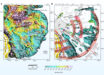
Left: 3D map of the electrical resistivity of the Earth’s crust and uppermost mantle in the southern Washington Cascades volcanic range; red colors indicate the geologic materials are electrically conductive, and blue colors indicate they are electrically resistive; the major volcanoes are marked with black cone symbols: MSH – Mount Saint Helens, MA – Mount Adams, GR – Goat Rocks, MT – Mount Rainier; the thin, bright colored band that lies immediately to the west of Mount Saint Helens is interpreted to result from relatively permeable metamorphosed sediments, mainly of marine origin, that are wedged between relatively impermeable and electrically resistive crustal blocks; the feature marked SLB is the Spirit Lake batholith, while underneath it the feature marked LCC is a Lower Crustal Conductor that is inferred to be a source of the partially molten material that trickles up from the mantle below and that is the source of the magmas that feed the Cascade volcanoes. Right: a cartoon sketch illustrating how the partially molten material from below may be diverted around the Spirit Lake batholith as it rises toward the surface; two zones of elevated seismic activity marked as MSZ and WRSZ are also seen to align along the electrically conductive feature seen in the resistivity image at the left. Image credit: Oregon State University.
Understanding the formation of Mount St. Helens begins with plate tectonics.
“Similar to the present day, where the Juan de Fuca plate is being subducted beneath North America, in the past crustal blocks with marine sediments were slammed into the continent, where they accreted,” Dr. Schultz said.
“This material is more permeable than surrounding rock and allows the magma to move through it.”
“The big batholith acts kind of like a plug in the crust and diverted magma that normally would have erupted in line with the other major Cascade volcanoes, resulting in St. Helens forming to the west of the Cascadia Arc, and Mt. Adams slightly to the east,” he said.
_____
Paul A. Bedrosian et al. Crustal inheritance and a top-down control on arc magmatism at Mount St Helens. Nature Geoscience, published online September 3, 2018; doi: 10.1038/s41561-018-0217-2