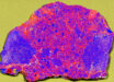
A new close-up image from NASA’s New Horizons robotic spacecraft reveals snowcapped mountains in the southernmost part of Pluto.

Snowcapped mountains in the southernmost part of Pluto. Image credit: NASA / Johns Hopkins University Applied Physics Laboratory / Southwest Research Institute.
This image was obtained by New Horizons’ Multispectral Visible Imaging Camera at a range of 21,100 miles (33,900 km) from Pluto, about 45 minutes before the spacecraft’s closest approach to the dwarf planet on July 14, 2015.
The area shown in the image is south of the dark equatorial band Cthulhu Regio, and southwest of the vast nitrogen ice plains Sputnik Planum.
A chain of bright mountains extends north into Cthulhu Regio. The mountains reveal themselves as snowcapped.
New Horizons compositional data indicate the bright snowcap material covering these mountains isn’t water, but methane that has condensed as frost onto these surfaces at high elevation.
Between some mountains are sharply cut valleys, which are each a few miles across and tens of miles long.
A similar valley system in the expansive plains to the east appears to be branched, with smaller valleys leading into it.
Members of the New Horizons science team think flowing nitrogen ice that once covered this area – perhaps when the ice in Sputnik Planum was at a higher elevation – may have formed these valleys.
The area is also marked by irregularly shaped, flat-floored depressions that can reach more than 50 miles (80 km) across and almost 2 miles (3 km) deep.
The great widths and depths of these depressions suggest that they may have formed when the surface collapsed, rather than through the sublimation of ice into the atmosphere.
New Horizons is currently 3.34 billion miles (5.38 billion km) from Earth and 311.4 million miles (501.1 million km) beyond Pluto, with all systems healthy and operating normally.
The spacecraft is on course for a flyby of the Kuiper Belt object 2014 MU69 in January 2019.