Dr Stuart Robbins, a New Horizons team member from the Southwest Research Institute in Boulder, Colorado, has produced a new animation/flyover of Pluto using images captured by the Long Range Reconnaissance Imager (LORRI) instrument on board NASA’s New Horizons probe.
“I primarily use these images to map craters across the surfaces of Pluto and its largest moon, Charon, to understand the population of impactors from the Kuiper Belt striking Pluto and Charon,” Dr Robbins explained.
“While this is my research focus, another interest of mine is figuring out how to make visualizations that convey some of the sheer beauty and power of the features New Horizons is revealing.”
He added: “since creating the Pluto flyby movie released in August 2015, I have used the latest images to produce an animation that shows what it might be like to take an aerial tour through Pluto’s thin atmosphere and soar above the surface that New Horizons explored.”
This animation begins low over the icy mountains Norgay Montes at a height of 120 miles. These mountains rise around 2 miles from the surrounding surface.
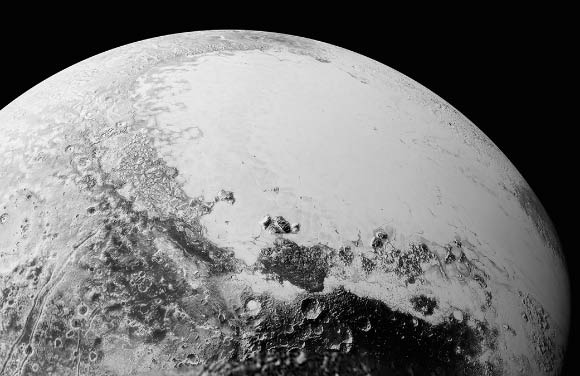
This view of Pluto, based on the latest images to be downlinked from NASA’s New Horizons spacecraft, shows what you would see if you were approximately 1,100 miles (1,800 km) above Pluto’s equatorial area, looking northeast over the dark, cratered, named Cthulhu Regio toward the bright, smooth, expanse of icy plains called Sputnik Planum. The entire expanse of terrain seen in this image is 1,100 miles (1,800 km) across. Image credit: NASA / Johns Hopkins University Applied Physics Laboratory / Southwest Research Institute.
“We head north over Sputnik Planum (bright area to the left) and Cthulhu Regio (dark area to the right),” Dr Robbins said.
“Our view steadily rises to a height of about 150 miles and turns to look east.”
“From this point, we drift slowly to the east, with Pluto’s north pole to the left, Tombaugh Regio filling much of the middle of the view, and older, more cratered areas standing out in marked contrast to the younger glaciers of Sputnik Planum.”
“As we continue to fly, our flight path rises to more than 1,500 miles with the final view of most of the disk that New Horizons saw on July 14, 2015.”