On August 25, 1989, NASA’s Voyager 2 spacecraft passed within about 40,000 km of Triton, the largest moon of the planet Neptune. In commemoration of the 25th anniversary of this event, Dr Paul Schenk of the Lunar and Planetary Institute in Houston has created a new high-resolution global map of the icy moon.

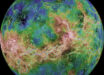
Colorized map of Triton based on Voyager 2 images. Image credit: NASA / JPL-Caltech / Lunar & Planetary Institute.
Discovered in 1846 by British astronomer William Lassell, just 17 days after the discovery of Neptune, Triton is the largest of Neptune’s 13 moons and the seventh-largest moon in the Solar System.
Triton has a diameter of 2,706 km and is locked in synchronous rotation with Neptune – one side faces the planet at all times.
Its thin atmosphere is composed mainly of nitrogen with small amounts of methane. This atmosphere most likely originates from volcanic activity, which is driven by seasonal heating by the Sun.
Most of our knowledge of the Triton’s surface was obtained by NASA’s Voyager 2, the only spacecraft so far to fly past the icy moon.
The spacecraft made a hair-raising pass over Triton in August 1989. Approaching from the deep south, it passed over the north pole of cloud-swept Neptune, almost close enough to brush the far-attenuated upper atmosphere. The gravity of Neptune pulled it down toward Triton, passing over the unlit north pole of the icy moon.

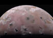
Map of Triton, polar view. Image credit: NASA / JPL-Caltech / Lunar & Planetary Institute.
Voyager 2’s historic footage has been used to construct the best-ever global color map of the moon.
The map has a nominal resolution of 600 m per pixel and is in orange, green and blue, showing Triton in approximately natural colors.
Because of the speed of Voyager 2’s visit and the slow rotation of Triton, only one hemisphere was seen clearly at close distance. The rest of the surface was either in darkness or seen as blurry markings.
NASA researchers say that the new map of Triton is also in support of the New Horizons Pluto encounter next year in July, 2015.