Sedimentological evidence and archaeological data show that huge tsunami hit the coast of today’s Sultanate of Oman around 1000 CE; the tsunami was almost 50 feet (15 m) tall and was caused by a strong earthquake in the Makran subduction zone, a giant fault that slants beneath the Arabian Sea coast of Pakistan and Iran.

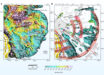
Overview of the study sites along the coastline of northern Oman: (a) Makran subduction zone (MSZ) and the Owen fracture zone (OFZ). White dots are earthquakes >M4.5; (b) the study site in Oman (black dots). Image credit: Hoffmann et al, doi: 10.1016/j.margeo.2019.106068.
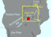
Oman is located at the northwestern part of the Arabian Sea. To the north, the Makran subduction zone marks the plate boundary between the Arabian Plate and Eurasia.
Great earthquakes on this 500-mile (800 km) long fault are capable of producing large tsunamis that hit the coast of the country.
Even with the most severe of these in recent times, the Makran event in 1945, the damage remained comparatively low. Back then, the tidal wave reached a height of 10 feet (3 m).
The new study shows that a much more powerful tsunami, with waves of up to 50 feet, hit the northern coast of Oman around 1,000 years ago.
“We concentrated our terrain investigations on a 124-mile (200 km) coastal strip in northeastern Oman,” said Dr. Gösta Hoffmann, a researcher in the Institute for Geosciences at the University of Bonn.
“We identified 41 large boulders, which were apparently carried inland by the force of the water.”
Some of the boulders were probably formed when the tsunami shattered parts of the cliffs.
For one of them, the largest weighing around 100 metric tons, the scientists were even able to determine the exact point at which it broke off.
They also radiocarbon dated marine organisms such as oysters and barnacles attached to some of the boulders.
“The measurements gave us a value of about 1,000 years,” Dr. Hoffmann said.
“This corresponds well with the dating results of clay fragments we found in tsunami sediments. They originate from vessels used by coastal dwellers.”
The Arabian and Eurasian plates move towards each other at a speed of about 1.6 inches (4 cm) per year. During this process, one plate slides beneath the other.
Sometimes they get stuck in this subduction zone. This can cause tensions that intensify more and more over years and decades.
If they suddenly come loose with a violent jolt, the water column above the plates starts to move. This can lead to the extremely destructive waves that are characteristic of tsunamis.
“So far it has been unclear to what extent the Arabian and Eurasian plates get stuck,” Dr. Hoffmann said.
“At the Makran event of 1945, for example, the effects were locally confined.”
“The current findings, however, suggest that the tensions can also build up and unload on a very large scale — there is no other feasible explanation for the enormous forces at work at the time.”
“It is therefore extremely important that a tsunami early warning system is put in place for this region.”
The findings were published in the journal Marine Geology.
_____
Gösta Hoffmann et al. 2020. Large Holocene tsunamis in the northern Arabian Sea. Marine Geology 419: 106068; doi: 10.1016/j.margeo.2019.106068