A grid of small polygons spotted by NASA’s Curiosity Mars rover may have originated as cracks in drying mud more than 3 billion years ago, according to the Curiosity science team.
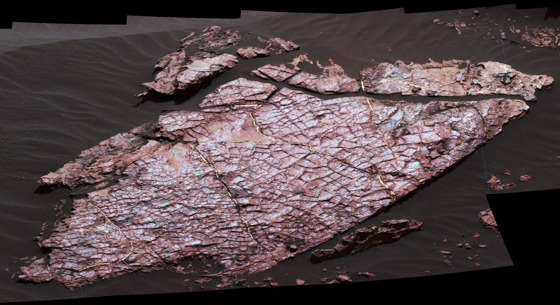
This view of a Martian rock slab called ‘Old Soaker,’ which has a network of cracks that may have originated in drying mud, comes from the Mast Camera on NASA’s Curiosity Mars rover. The location is within an exposure of Murray formation mudstone on lower Mount Sharp inside Gale Crater. Mud cracks would be evidence of a time more than 3 billion years ago when dry intervals interrupted wetter periods that supported lakes in the area. Several images from Mast Camera’s left-eye camera are combined into this mosaic view. They were taken on Dec. 20, 2016, during the 1,555th sol of Curiosity’s work on Mars. The Old Soaker slab is about 4 feet (1.2 m) long. Image credit: NASA / JPL-Caltech / MSSS.
“Mud cracks are the most likely scenario here,” said Nathan Stein, a graduate student at Caltech and Curiosity science team member, who led the investigation of a site called Old Soaker, on lower Mount Sharp, Mars.
“If this interpretation holds up, these would be the first mud cracks — technically called desiccation cracks — confirmed by the mission.”
“They would be evidence that the ancient era when these sediments were deposited included some drying after wetter conditions.”
Curiosity has found evidence of ancient lakes in older, lower-lying rock layers and also in younger mudstone that is above Old Soaker.
“Even from a distance, we could see a pattern of four- and five-sided polygons that don’t look like fractures we’ve seen previously with Curiosity. It looks like what you’d see beside the road where muddy ground has dried and cracked,” Stein said.
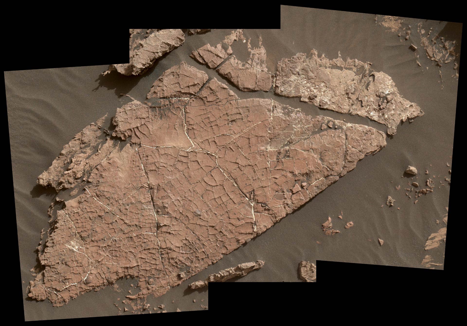
The network of cracks in Old Soaker may have formed from the drying of a mud layer more than 3 billion years ago. The view spans about 4 feet (1.2 m) left-to-right and combines three images taken by the Mars Hand Lens Imager (MAHLI) camera on the arm of Curiosity. Mud cracks would be evidence of a time when dry intervals interrupted wetter periods that supported lakes in the area. MAHLI was positioned about 3 feet (90 cm) above the surface when it took the component images on Dec. 31, 2016, during the 1,566th sol of Curiosity’s work on Mars. This observation was planned as part of assessing a hypothesis that the target preserves evidence of drying mud. The slab bears a network of four- and five-sided polygons about half an inch to 1 inch (1 to 2 cm) across, which matches the pattern commonly formed when a thin layer of mud dries. Some edges of the polygons are ridges of material the same color as the surrounding rock. The target rock’s name comes from the name of an island off the coast of Maine. The names informally assigned by the rover team to features in the area of lower Mount Sharp that includes this slab are from a list of islands, hills and other sites in or near Maine’s Bar Harbor. Image credit: NASA / JPL-Caltech / MSSS.
The cracked layer formed more than 3 billion years ago and was subsequently buried by other layers of sediment, all becoming stratified rock. Later, wind erosion stripped away the layers above Old Soaker.
Material that had filled the cracks resisted erosion better than the mudstone around it, so the pattern from the cracking now appears as raised ridges.
Cracks that form at the surface, such as in drying mud, generally fill with windblown dust or sand.
A different type of cracking with plentiful examples found by the rover occurs after sediments have hardened into rock.
Pressure from accumulation of overlying sediments can cause underground fractures in the rock. These fractures generally have been filled by minerals delivered by groundwater circulating through the cracks, such as bright veins of calcium sulfate.
Both types of crack-filling material were found at Old Soaker. This may indicate multiple generations of fracturing: mud cracks first, with sediment accumulating in them, then a later episode of underground fracturing and vein forming.
“If these are indeed mud cracks, they fit well with the context of what we’re seeing in the section of Mount Sharp Curiosity has been climbing for many months,” said Dr. Ashwin Vasavada, Curiosity project scientist at NASA’s Jet Propulsion Laboratory.
“The ancient lakes varied in depth and extent over time, and sometimes disappeared. We’re seeing more evidence of dry intervals between what had been mostly a record of long-lived lakes.”
Besides the cracks that are likely due to drying, other types of evidence observed in the area include sandstone layers interspersed with the mudstone layers, and the presence of a layering pattern called cross-bedding. This pattern can form where water was flowing more vigorously near the shore of a lake, or from windblown sediment during a dry episode.
The Curiosity team is continuing to analyze data acquired at the possible mud cracks and also watching for similar-looking sites.
_____
This article is based on a press-release from NASA’s Jet Propulsion Laboratory.