A study published in the Journal of Geophysical Research: Planets provides new evidence for a warm early Mars that hosted water across a geologically long timescale, rather than in short episodic bursts.

This false-color map, produced by the Mars Orbiter Laser Altimeter (MOLA), depicts the topography of the Martian surface. Hellas basin, the large, dark blue region below the center, has a diameter of 1,430 miles (2,300 km), and is one of the largest identified impact craters both on Mars and within the Solar System. It is thought to have formed some 4 billion years ago. Image credit: MOLA Science Team.
Although water is known to have once flowed on Mars, the nature and timeline of how and when it did so is a major open question within planetary science.
The findings follow an analysis of a region of relatively smooth terrain, called inter-crater plains, just north of the Hellas basin, which is one of the largest identified impact craters both on Mars and within the Solar System, and is thought to have formed some 4 billion years ago.
“These plains on the northern rim of Hellas are usually interpreted as being volcanic, as we see with similar surfaces on the Moon,” said lead author Dr. Francesco Salese, from Nantes University in France and the Universita ‘Gabriele D’Annunzio’ in Italy.
“However, our work indicates otherwise. Instead, we found thick, widespread swathes of sedimentary rock.”
Sedimentary and volcanic (igneous) rocks form in different ways — volcanic, as the name suggests, needs active volcanism driven by a planet’s internal activity, while sedimentary rock usually requires water.
Igneous rock is created as volcanic deposits of molten rock cool and solidify, while sedimentary builds up as new deposits of sediment form layers that compact and harden over geologically long timescales.
“To create the kind of sedimentary plains we found at Hellas, we believe that a generally aqueous environment was present in the region some 3.8 billion years ago (Noachian period),” Dr. Salese said.
“Importantly, it must have lasted for a long period of time — on the order of hundreds of millions of years.”
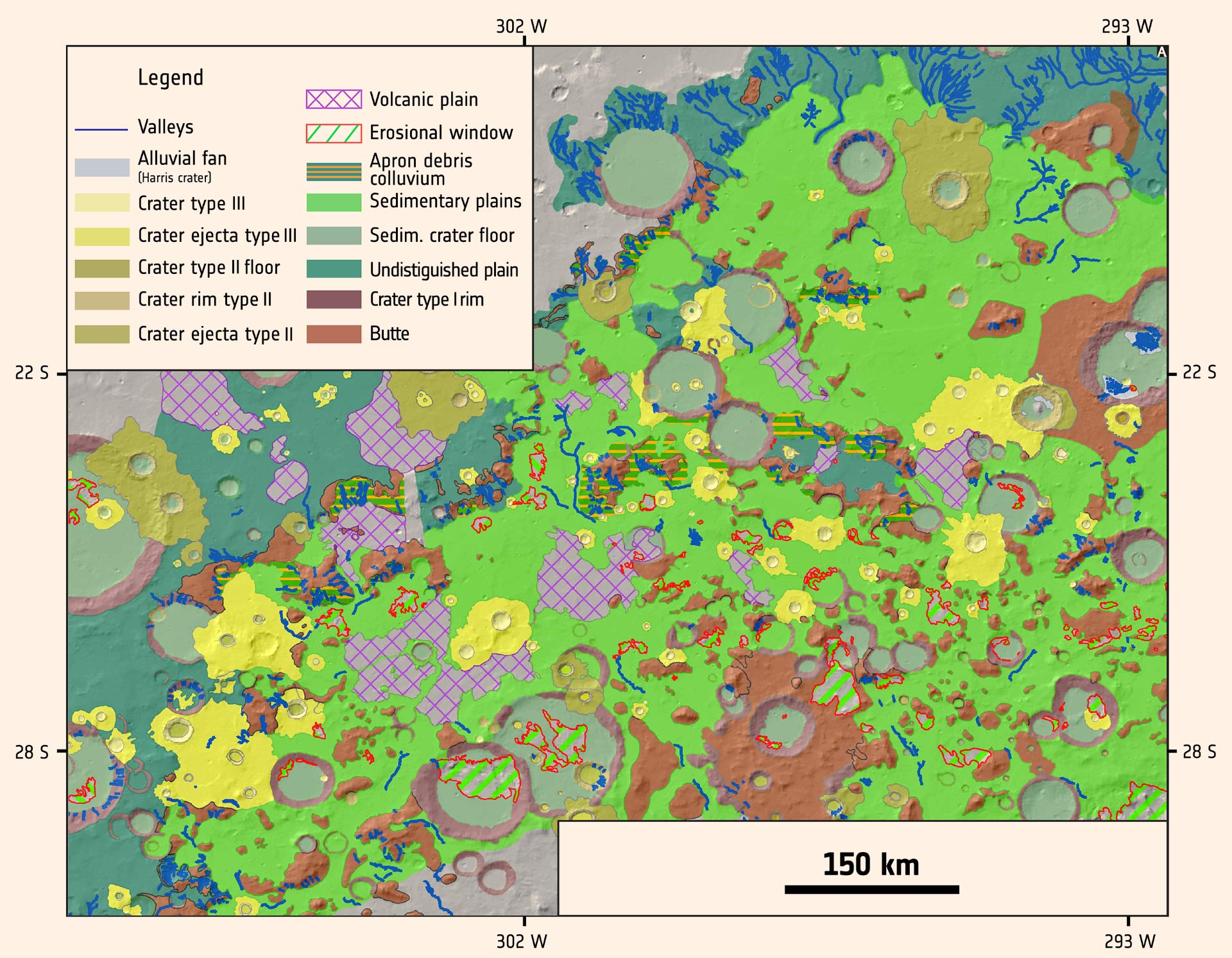
This detailed geological map of the intercrater plains north of the Hellas basin was produced by Salese et al using images from the Mars Express High-Resolution Stereo Camera (HRSC), the Mars Reconnaissance Orbiter (MRO) High Resolution Imaging Science Experiment (HiRISE), and Context (CTX) camera. The data from Mars Express and MRO allowed the scientists to explore the region’s appearance, topography, morphology, mineralogy, and age. More specifically, Mars Express imaging data allowed them to study the plains’ geology on a regional scale, providing context for the local-scale observations from MRO. Analysis of the map provides new evidence for a warm young Mars that hosted water across a geologically long timescale. Image credit: Salese et al, doi: 10.1002/2016JE005039.
Dr. Salese and his colleagues from Italy and France used imaging and spectro-imaging data from ESA’s Mars Express and NASA’s Mars Reconnaissance Orbiter to create a detailed geological map of the area around northern Hellas, taking advantage of so-called ‘erosional windows’ — geological formations that act as natural ‘drill holes’ down into the plains, revealing deeper material.
These data showed the plains to be composed of an over 1,600-foot (500 m) thick band of flat, layered, light-colored rock.
The rock showed several characteristics typical of sedimentary deposition: box-work, which is a type of box-like mineral structure formed by erosion; cross-bedding, identified as layers of rock intersecting at different tilts and inclines; and planar stratification, which manifests as distinct, near-horizontal layers of rock that line up atop one another. These were in addition to large amounts of clays known as smectites.
Clays are exciting chemicals, as they indicate that a wet and thus potentially habitable environment once existed at that location. Clays can also trap organic material and potentially preserve signs of life.
“These characteristics suggest that the rock didn’t form from lava flow deposits but rather from sedimentary processes, which implies that the region once experienced warm and wet conditions for a relatively long time,” Dr. Salese said.
“When the layered rock was deposited — during the Noachian period — its surroundings must have been soaked in water, with intense liquid circulation.”
“We think it likely formed in a lake (lacustrine) or stream (alluvial) environment, or a combination of both.”
The rock then underwent an intense period of volcanic erosion during the Hesperian period (3.7 to 3.3 billion years ago) and was covered by volcanic flows, creating the morphology we see today.
The researchers estimate a minimum erosion rate for this time period of one meter per million years — 100 times higher than the erosion rates estimated on Mars in the past 3 billion years.
“This is further evidence of a prolonged period of active geological processes on the surface of early Mars,” said co-author Dr. Nicolas Mangold, of Nantes University.
“We can also extrapolate our finding to the rest of Mars and be confident we understand the evolution of the planet as a whole — we believe that the global climate conditions of Noachian Mars were sufficient to support significant liquid water.”
_____
Francesco Salese et al. 2016. A sedimentary origin for intercrater plains north of the Hellas basin: Implications for climate conditions and erosion rates on early Mars. Journal of Geophysical Research: Planets 121 (11): 2239-2267; doi: 10.1002/2016JE005039
This article is based on a press-release from the European Space Agency.