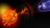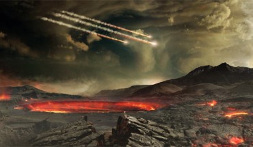
When and how the Earth evolved from a molten mass into a rocky planetary body continually resurfaced by plate tectonics remain some of the biggest questions in earth sciences. According to new research by scientists from Macquarie University, Southwest Research Institute and Harvard University, this transition may have been triggered by intense extraterrestrial bombardment. An artist’s concept of meteors impacting the ancient Earth. Image credit:...


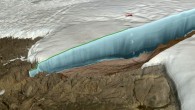
![Backscattered electron images of experimental charges. Locations of images (A) to (D) from sediment-peridotite reaction experiments are schematically shown in capsule on the left. (A, C, and D) - reaction experiments at 5 GPa/1000 degrees Celsius with superimposed energy-dispersive x-ray maps of chlorine [green in (C) and (D)]. The sediment half of two-layer experiments recrystallized to garnet and clinopyroxene (Cpx), whereas orthopyroxene (Opx), magnesite (Mgs), and Na-K chlorides formed at the leading edge of the reaction zone against the peridotite. (B) - peridotite layer in the reaction experiment at 3 GPa/900 degrees Celsius contained phlogopite (Phl) behind the magnesite plus orthopyroxene zone, and Na-K chlorides were absent. (E and F) - sediment melting experiment (no peridotite included) at 4 GPa/1000 degrees Celsius showing silicate melt (E) in equilibrium with garnet (Gt), coesite (Coe), and Mg calcite (Mg-Cc) shown in (F). Scale bars - 100 μm (A and B) and 20 μm (C to F). Image credit: Förster et al, doi: 10.1126/sciadv.aau2620.](https://cdn.sci.news/images/2019/05/image_7241-Diamond-Salts-195x110.jpg)