The dwarf planet Ceres hosts permanently shadowed areas in its polar regions, and these regions are an interesting analog to Mercury and the Moon. Ceres’...
To study dark energy’s effects over the past 11 billion years, the Dark Energy Spectroscopic Instrument (DESI) has created the largest 3D map of our...
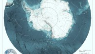
Scientists aboard the research vessel Atlantis have discovered five new deep-sea hydrothermal vent sites on the seafloor at 2,550 m (1.6 miles) depth....
Using data from ESA’s ExoMars Trace Gas Orbiter and NASA’s Mars Reconnaissance Orbiter, planetary scientists have created the 1:30000 scale geological...
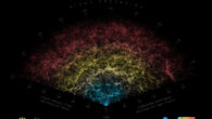
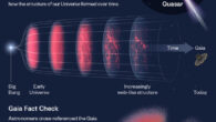
The new map, dubbed Quaia, includes around 1,295,502 quasars from across the visible Universe and could help astronomers better understand the properties...
Hercules X-1 is an X-ray binary system in which a neutron star is drawing material away from a Sun-like star. This neutron star’s accretion disk is unique...
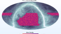
Using data from NSF’s Atacama Cosmology Telescope, astronomers have produced the most detailed map of dark matter distributed across one quarter of the...
There are many thousands of volcanoes on the surface of Venus. These volcanoes provide clues into the interior properties of the planet, properties that...
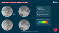
The newly-released map shows the locations and abundances of secondary minerals formed through interaction with water on Mars. It is based on the analysis...
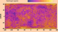
The new global map of bulk hydrogen abundances on the Moon’s surface allows planetary researchers to address many previously unexplored areas in the...
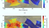
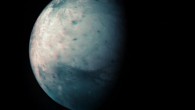
The new mid-ultraviolet (UV) maps of Europa, created using data from the Space Telescope Imaging Spectrograph (STIS) instrument aboard the NASA/ESA Hubble...
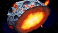
The Atacama Large Millimeter/submillimeter Array located on the Chajnantor Plateau in Chile allowed the acquisition of temperature images of (16) Psyche,...
After nine years of gathering, cleaning, processing and interpolating data, an international team of researchers this week released the second version...
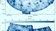
In the second data release from the ongoing LOw-Frequency ARray (LOFAR) Two-metre Sky Survey, astronomers present radio images covering 27% of the northern...
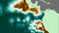
A duo of MIT researchers has created the most detailed atlas of the world’s largest oxygen deficient zones, biogeochemical regions of the global ocean...
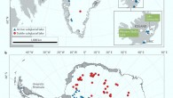
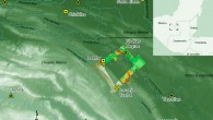
Using the high-resolution airborne LiDAR data, archaeologists have found extensive systems of sophisticated irrigation and terracing in and outside the...
Using data from the Jovian Infrared Auroral Mapper (JIRAM) instrument onboard NASA’s Juno spacecraft, researchers have produced a new infrared map of...