An international team of planetary researchers from the University of Arkansas and elsewhere has produced a high-resolution geologic map of the Schrödinger basin, the second-youngest impact basin on the Moon.

View of the southern, midlatitude far side of the Moon showing the South Pole-Aitken basin outlined in white and the Schrödinger basin outlined in yellow. Image credit: Czaplinski et al., doi: 10.3847/PSJ/abdb34.
The 320-km-diameter Schrödinger basin is the second youngest impact basin residing within the South Pole-Aitken basin.
It contains a 150-km peak-ring structure ranging in elevation from 1 to 2.5 km above the basin floor.
In 2012, a study of lunar landing sites revealed that the Schrödinger basin is a high-priority site for future missions, because more of the science objectives identified for NASA can be accomplished there than at any other location on the Moon.
“When the Schrödinger basin was formed, some of its lithologies — the general physical characteristics of the rocks — may have been uplifted from very deep below the lunar surface,” said Ellen Czaplinski, a Ph.D. student in the Arkansas Center for Space and Planetary Sciences at the University of Arkansas.
“Therefore, investigating these rocks up close is extremely important for answering high-priority science goals.”
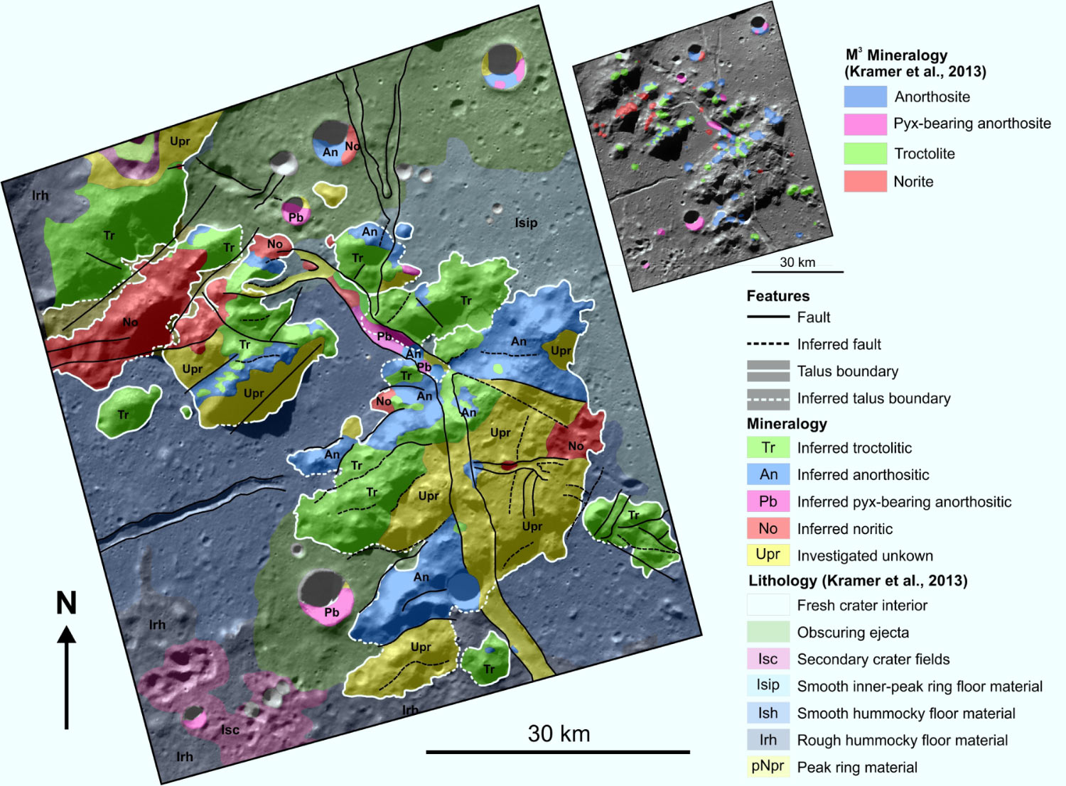
Geologic map of the southwest peak-ring area of the Schrödinger basin, including structural features, geologic units and inferred lithologies in the peak ring. Image credit: Czaplinski et al., doi: 10.3847/PSJ/abdb34.
Along with the map, Czaplinski and colleagues created three potential paths for robotic rovers to travel through the Schrödinger basin to collect high-priority rock samples.
“In 2007, the National Research Council outlined scientific objectives and goals of future lunar missions, including exploration of the South Pole-Aitken basin, the oldest and deepest impact basin on the Moon,” Czaplinski said.
“Because the Schrödinger basin is located within the South Pole-Aitken basin, it presents a unique opportunity to study rocks that possibly originated deep below the surface.”
“Many of these rock types are exposed at the surface in multi-kilometer long exposures of rock outcrops in Schrödinger’s peak ring, an inner ring of uplifted rocks that formed with the basin.”
“Sampling these rocks within the peak ring provides high scientific potential for further understanding the context of Schrödinger’s lithologies.”
The new map is described in a paper in the Planetary Science Journal.
_____
E.C. Czaplinski et al. 2021. Human-assisted Sample Return Mission at the Schrödinger Basin, Lunar Far Side, Using a New Geologic Map and Rover Traverses. Planet. Sci. J 2, 51; doi: 10.3847/PSJ/abdb34