In new research, led by the University of California, Santa Cruz and Princeton University, scientists reconstructed the history of sea level at the Bering Strait, a strait between the Pacific and Arctic oceans, separating Asia and North America. Their results show that the growth of the ice sheets — and the resulting drop in sea level — occurred surprisingly quickly and much later in the glacial cycle than previous studies had suggested.

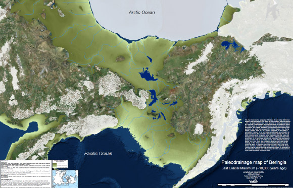
This map illustrates the geography of Beringia, the land bridge that formed between North America and Asia during the last glaciation. Humans crossed Beringia from Asia to North America during the glacial period depicted on this map. Lakes and drainages have been reconstructed to provide a better perspective on the environment of the land mass according to bathymetric data having a grid spacing of 1 km (100 m for Norton Sound). Some of the lake basins are shallow and may have been wetlands rather than open water bodies. Image credit: J.D. Bond / Yukon Geological Survey / Government of Yukon.
Global sea levels drop during ice ages as more and more of Earth’s water gets locked up in massive ice sheets, but the timing of these processes has been hard to pin down.
During the Last Glacial Maximum, which lasted from about 26,500 to 19,000 years ago, ice sheets covered large areas of North America.
Dramatically lower sea levels uncovered a vast land area known as Beringia that extended from Siberia to Alaska and supported herds of horses, mammoths, and other Pleistocene fauna.
As the ice sheets melted, the Bering Strait became flooded again around 13,000 to 11,000 years ago.
“Our results mean that more than 50% of the global ice volume at the Last Glacial Maximum grew after 46,000 years ago,” said University of California, Santa Cruz’s Dr. Tamara Pico, corresponding author of the study.
“This is important for understanding the feedbacks between climate and ice sheets, because it implies that there was a substantial delay in the development of ice sheets after global temperatures dropped.”
The new findings are interesting in relation to human migration because they shorten the time between the opening of the land bridge and the arrival of humans in the Americas.
The timing of human migration into North America remains unresolved, but some studies suggest people may have lived in Beringia throughout the height of the Ice Age.
“People may have started going across as soon as the land bridge formed,” Dr. Pico said.
To determine when the Bering Strait was flooded during the past 46,000 years, Dr. Pico and her colleagues performed an analysis of nitrogen isotopes in seafloor sediments.
They measured nitrogen isotope ratios in the remains of marine plankton preserved in sediment cores collected from the seafloor at three locations in the western Arctic Ocean.
Because of differences in the nitrogen composition of Pacific and Arctic waters, they were able to identify a nitrogen isotope signature indicating when Pacific water flowed into the Arctic.
They then compared the results with sea level models based on different scenarios for the growth of the ice sheets.
“The exciting thing to me is that this provides a completely independent constraint on global sea level during this time period,” Dr. Pico said.
“Some of the ice sheet histories that have been proposed differ by quite a lot, and we were able to look at what the predicted sea level would be at the Bering Strait and see which ones are consistent with the nitrogen data.”
“The results support recent studies indicating that global sea levels were much higher prior to the Last Glacial Maximum than previous estimates had suggested.”
The findings appear this week in the Proceedings of the National Academy of Sciences.
_____
Jesse Farmer et al. 2022. The Bering Strait was flooded 10,000 years before the Last Glacial Maximum. PNAS, in press; doi: 10.1073/pnas.2206742119


