The new map and digital dataset, named Itiner-e, increase the known length of the Roman Empire’s road system by over 110,000 km.
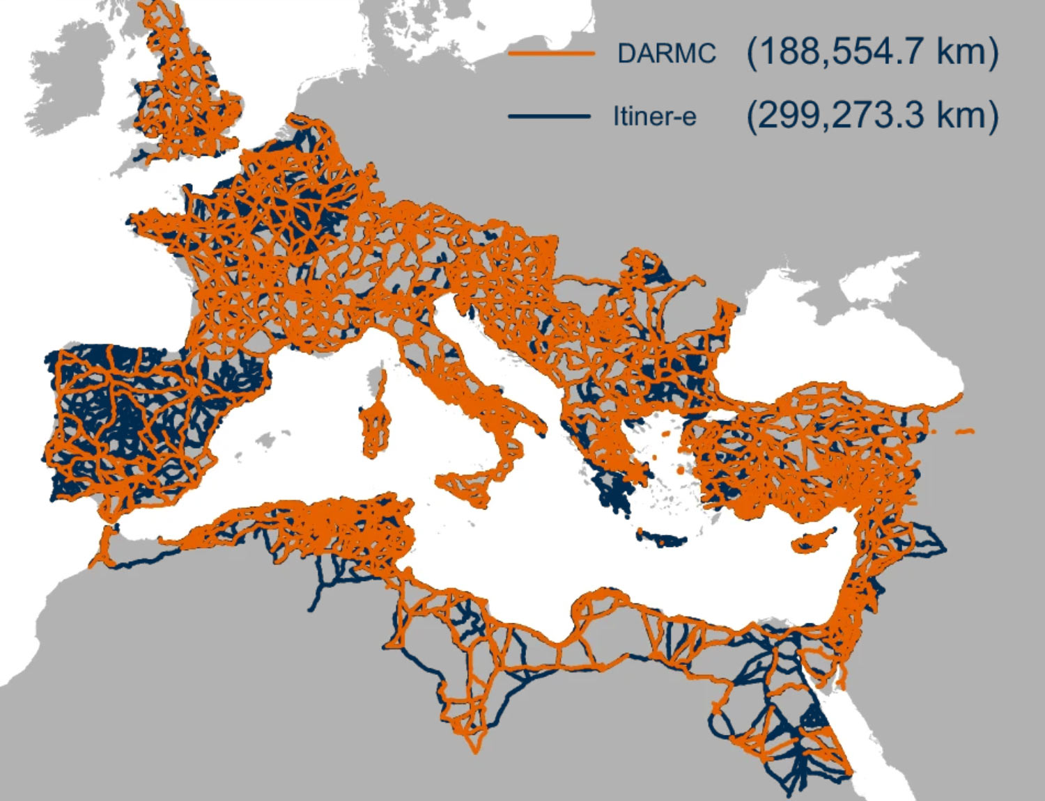
Itiner-e is the most detailed and comprehensive open digital dataset of roads in the entire Roman Empire. Image credit: de Soto et al., doi: 10.1038/s41597-025-06140-z.
At its height in the second century CE, the Roman Empire included over 55 million people and stretched from modern day Britain to Egypt and Syria.
Although a network of roads throughout the Empire facilitated its development and maintenance, it remains incompletely mapped and existing digitizations are low resolution.
“The study of roads of the Roman Empire is a centuries-old pursuit,” said Aarhus University researcher Tom Brughmans and his colleagues.
“There is a wealth of information about roads that were physically identified in archaeological excavations and surveys, about milestones which were placed at regular intervals along Roman roads, and historical sources like the Antonine Itinerary or the Tabula Peutingeriana, describing major connections between settlements, as well as detailed regional summaries on Roman roads.”
“However, finding and locating this diversity of research and the spatially precise locations of the roads themselves is inhibited by a lack of an Empire-wide synthesis and digitization.”
The researchers created Itiner-e using archaeological and historical records, topographic maps, and satellite imagery.
The dataset includes 299,171 km of roads — an increase from a previous estimate of 188,555 km — covering almost 4 million km2.
The scientists attribute this increase in road coverage to higher coverage of roads in the Iberian Peninsula, Greece and North Africa and to the adapting of previously proposed road routes to fit geographical realities.
This includes allowing roads crossing mountains to follow winding paths rather than direct lines.
Itiner-e comprises 14,769 road sections, with 103,478 km (34.6%) classified as main roads and 195,693 km (65.4%) as secondary roads.
The precise locations of only 2.7% of the roads are known with certainty, while 89.8% are less precisely known, and 7.4% are hypothesized.
“Itiner-e represents the most detailed and comprehensive openly accessible digitization of the Roman Empire’s roads and that it also highlights gaps in current knowledge of the road system,” the authors said.
“They note that Itiner-e cannot show changes in the road system over time and that future research is needed to investigate this throughout the Roman Empire.”
“Itiner-e could be used in future research investigating the influence of Roman roads on connectivity, administration, migration, and disease transmission in the Empire.”
The map and dataset were described in a paper in the journal Scientific Data.
_____
P. de Soto et al. 2025. Itiner-e: A high-resolution dataset of roads of the Roman Empire. Sci Data 12, 1731; doi: 10.1038/s41597-025-06140-z