ESA’s Mars Express orbiter has used radar signals bounced through underground layers of ice to find evidence of liquid water trapped below the south polar cap of the Red Planet. The results appear today in the journal Science.

An artist’s impression of ESA’s Mars Express spacecraft. Image credit: ESA / ATG Medialab / DLR / FU Berlin / CC BY-SA 3.0 IGO.
Evidence for Mars’ watery past is prevalent across its surface in the form of vast dried-out river valley networks and gigantic outflow channels clearly imaged by orbiting spacecraft.
Orbiters, together with landers and rovers exploring the Martian surface, also discovered minerals that can only form in the presence of liquid water.
But the climate has changed significantly over the course of the planet’s 4.6 billion year history and liquid water cannot exist on the surface today, so scientists are looking underground.
Early results from Mars Express already found that water-ice exists at the planet’s poles and is also buried in layers interspersed with dust.
The presence of liquid water at the base of the polar ice caps has long been suspected; after all, from studies on Earth, it is well known that the melting point of water decreases under the pressure of an overlying glacier.
Moreover, the presence of salts on Mars could further reduce the melting point of water and keep the water liquid even at below-freezing temperatures.
But until now evidence from Mars Express’ MARSIS (Mars Advanced Radar for Subsurface and Ionosphere Sounding) instrument, the first radar sounder ever to orbit another planet, remained inconclusive.
“We’d seen hints of interesting subsurface features for years but we couldn’t reproduce the result from orbit to orbit, because the sampling rates and resolution of our data was previously too low,” said MARSIS operations manager Dr. Andrea Cicchetti, a researcher at the Istituto di Astrofisica e Planetologia Spaziali, Istituto Nazionale di Astrofisica, Roma, Italy.
“We had to come up with a new operating mode to bypass some onboard processing and trigger a higher sampling rate and thus improve the resolution of the footprint of our dataset: now we see things that simply were not possible before.”

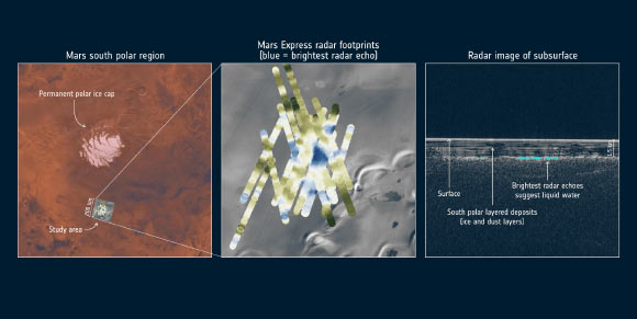
Twenty-nine observations were made between 2012 and 2015 in the Planum Australe region at the south pole using the MARSIS radar on ESA’s Mars Express spacecraft. The 200 km square study area is indicated in the left-hand image and the radar footprints on the surface are indicated in the middle image for multiple orbits. The grayscale background image is a Thermal Emission Imaging System image from NASA’s Mars Odyssey, and highlights the underlying topography: a mostly featureless plain with icy scarps in the lower right (south is up). The footprints are color-coded corresponding to the ‘power’ of the radar signal reflected from features below the surface. The large blue area close to the center corresponds to the main radar-bright area, detected on many overlapping orbits of the spacecraft. A subsurface radar profile is shown in the right hand panel for one of the Mars orbits. The bright horizontal feature at the top represents the icy surface of Mars in this region. The south polar layered deposits — layers of ice and dust — are seen to a depth of about 1.5 km. Below is a base layer that in some areas is even much brighter than the surface reflections, highlighted in blue, while in other places is rather diffuse. Analyzing the details of the reflected signals from the base layer yields properties that correspond to liquid water. The brightest reflections are centered around 193 degrees E/81 degrees S in the intersecting orbits, outlining a well-defined, 20 km-wide zone. Image credit: NASA / Viking / JPL-Caltech / Arizona State University / ESA / ASI / University of Rome / R. Orosei et al.
Between May 2012 and December 2015, Dr. Cicchetti and colleagues used MARSIS to survey a region called Planum Australe, located in the southern ice cap of Mars.
Thr team obtained 29 sets of radar samplings, mapping out an area exhibiting a very sharp change in its associated radar signal, about 1.5 km below the surface of the ice and extending sideways about 20 km.
The radar profile of this area is similar to that of lakes of liquid water found beneath the Antarctic and Greenland ice sheets on Earth, suggesting that there is a subglacial lake at this location on Mars.
“This subsurface anomaly on Mars has radar properties matching water or water-rich sediments,” said MARSIS principal investigator Dr. Roberto Orosei, a researcher at the Istituto di Radioastronomia, Istituto Nazionale di Astrofisica, Bologna, Italy.
“This is just one small study area; it is an exciting prospect to think there could be more of these underground pockets of water elsewhere, yet to be discovered.”
“This thrilling discovery is a highlight for planetary science and will contribute to our understanding of the evolution of Mars, the history of water on our neighbor planet and its habitability,” said Mars Express project scientist Dr. Dmitri Titov, who was not involved in the study.
_____
R. Orosei et al. Radar evidence of subglacial liquid water on Mars. Science, published online July 25, 2018; doi: 10.1126/science.aar7268


