This new image from ESA’s Mars Express orbiter shows the planet’s south polar ice cap and ancient, cratered highlands.
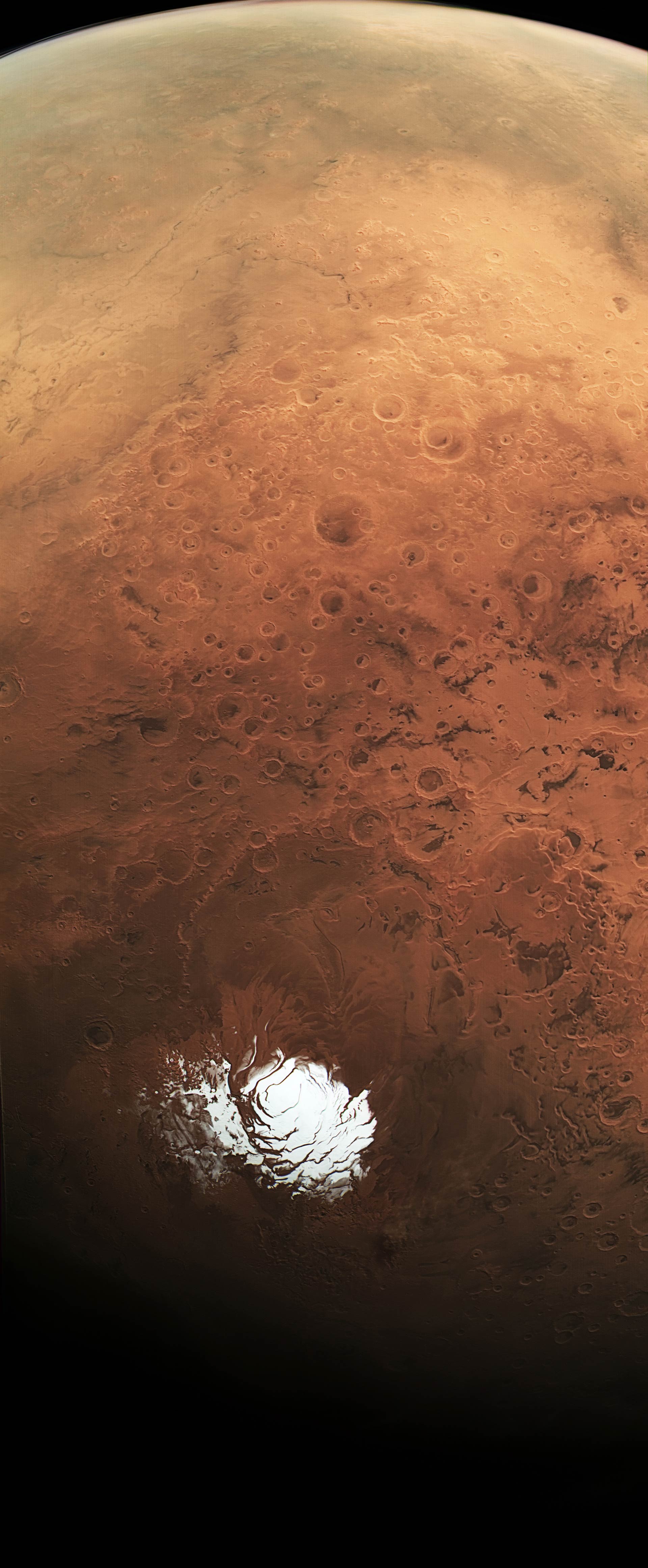
The high-resolution HRSC camera aboard ESA’s Mars Express captured this image on February 25, 2015, from a distance of 6,150 miles (9,900 km). The image was created using data from the nadir channel, the field of view of which is aligned perpendicular to the surface of Mars, and the color channels of HRSC. These channels have been co-registered using markers on the surface, such as a mountain or dark spot, to achieve a common geometry. That is, for each color channel, these markers are overlain to produce the color image. This process is not needed for normal nadir observations because the geometry is known here, unlike in this observation. Image credit: ESA / DLR / FU Berlin / CC BY-SA 3.0 IGO.
During normal scientific imaging, Mars Express’ High/Super Resolution Stereo Colour Imager (HRSC) takes images pointing straight down towards the surface, from around the closest point to the planet along the spacecraft’s elliptical orbit at an altitude of about 185 miles (300 km).
But in this unusual observation, the orbiter turned such that its camera panned over the surface far above the planet, close to its furthest point along its orbit, in this case at around 6,150 miles (9,900 km).
Importantly, as well as affording an unusual wide view, this allows the HRSC camera to record a range of features at the same illumination conditions, allowing essential calibration of the camera’s sensors.
Towards the bottom of the image above is the planet’s south polar ice cap, comprising frozen water and carbon dioxide ice. This feature changes in size and shape with the seasons.
The image was captured during the south polar summer, but during winter the ice extends into the smooth regions that can be seen surrounding it.

Mars’ south polar ice cap. Image credit: ESA / DLR / FU Berlin / CC BY-SA 3.0 IGO.
The mid-section of the image corresponds to the planet’s ancient southern highlands – it is covered by a high density of impact craters of varying size and states of erosion, with many craters overlapping.
Numerous patterns of dark, dusty dune deposits are also visible, swept up by wind and accumulating in impact craters and troughs.
Towards the top left of the image a portion of the giant Hellas basin can be seen. This feature spans more than 1,360 miles (2,200 km) across and plunges some 5 miles (8 km) below the surface.
Two prominent channels – Dao Vallis and Niger Vallis – can be seen breaching the basin rim.
Hazy patches seen in the upper part of the image are attributed to clouds, while a thin, delicate layer of atmosphere follows the curvature of the planet at the horizon.