NASA scientists have created the best-ever global map of Charon, using images taken by New Horizons’ Long Range Reconnaissance Imager in July 2015.

Global map of Charon as of July 30, 2015. The map is in simple cylindrical projection, with zero longitude (the Pluto-facing direction) in the center. It includes all available resolved images of the moon’s surface captured between July 7-14, 2015 on the anti-Pluto facing hemisphere. Image credit: NASA / Johns Hopkins University Applied Physics Laboratory / Southwest Research Institute.
Charon, the largest of the known moons of Pluto, was discovered in June 1978 by astronomer James Christy of the U.S. Naval Observatory (USNO), using the 1.55-m telescope at USNO’s Flagstaff Station.
The icy moon has a diameter of 750 miles (1,207 km) and an estimated mass approximately one-eighth that of Pluto.
It is so big that Pluto and Charon are sometimes referred to as a double dwarf planet.
It orbits a common center of gravity with Pluto, and the two objects are tidally locked together as they orbit.
Charon’s orbit around Pluto takes 6.4 Earth days, and one Pluto rotation takes 6.4 Earth days.
The distance between them is 12,200 miles (19,640 km).

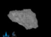
This image of Pluto’s largest moon Charon was taken on July 13 from a distance of 289,000 miles. Image credit: NASA / Johns Hopkins University Applied Physics Laboratory / Southwest Research Institute.
The new map of Charon includes all available resolved images of the icy moon’s surface obtained between July 7-14, 2015, at pixel resolutions ranging from 24 miles (40 km) on the anti-Pluto facing hemisphere (left and right sides of the map), to 1,250 feet (400 m) per pixel on portions of the Pluto-facing hemisphere – the side facing New Horizons when it flew past the planet – at map center.
Many additional images of Charon’s surface now stored in the memory of the probe’s data recorders are expected to be transmitted to Earth in the months to come.