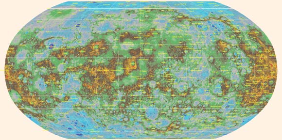
A team of scientists from NASA, the U.S. Geological Survey, Arizona State University, Carnegie Institute of Washington and Johns Hopkins University Applied Physics Laboratory has created the first global topographic map of the planet Mercury.

Topographic map of Mercury with labeled features. Mercury’s surface is colored according the topography of the surface, with regions with higher elevations colored brown, yellow and red, and regions with lower elevations appearing blue and purple. The highest elevation on the planet is located just south of the equator, and about 2.5 miles above Mercury’s average elevation. The lowest elevation, which is more than three miles below Mercury’s average, is found on the floor of Rachmaninoff basin, a basin suspected to host some of the most recent volcanic deposits on the planet. Image credit: NASA / U.S. Geological Survey / Arizona State University / Carnegie Institution of Washington / Johns Hopkins University Applied Physics Laboratory.
Before the launch of NASA’s MErcury Surface, Space ENvironment, GEochemistry, and Ranging (MESSENGER) spacecraft, little was known about Mercury.
Launched in August 2004, the spacecraft traveled 4.9 billion miles – a journey that included 15 trips around the Sun and flybys of Earth once, Venus twice and Mercury three times – before it was inserted into orbit around its target planet in March 2011.
Although it completed its primary science objectives by March 2012, MESSENGER’s mission was extended two times, allowing it to capture additional images and information about the planet in unprecedented detail.
Its voyage to Mercury surpassed expectations and ended with its descent and impact onto the surface on April 30, 2015.
A team of researchers from five institutions and agencies in the United States used data from MESSENGER to produce a highly detailed topographic map, similar to the type of map used by hikers to illustrate elevation changes and landforms.
“The creation of this map is a prime example of the utility and beauty that can come out of overcoming complex cartographic problems,” said Lazlo Kestay, USGS Astrogeology Science Center Director.
“This highly aesthetic product literally provides a whole new dimension to the study of Mercury images, opening many new paths to understanding the surface, interior, and past of the closest planet to the Sun.”
This new map reveals a variety of interesting topographic features, including the highest and lowest points on Mercury.
The highest elevation on the planet is at 2.78 miles (4.48 km) above Mercury’s average elevation, located just south of the equator in some of Mercury’s oldest terrain.
The lowest elevation, at 3.34 miles (5.38 km) below Mercury’s average, is found on the floor of Rachmaninoff basin, an intriguing double-ring impact basin suspected to host some of the most recent volcanic deposits on the planet.
“This product reveals the entirety of the innermost planet of the Solar System, less than half glimpsed during the three flybys of Mercury carried out by the Mariner 10 spacecraft over 40 years ago,” said MESSENGER team member Dr. Ralph McNutt, from Johns Hopkins University Applied Physics Laboratory.
“As such, it is yet another indicator of the turning point from reconnaissance through exploration of Mercury by MESSENGER to an era of intensive study of Mercury in years to come.”
“During its four years of orbital observations, MESSENGER revealed the global characteristics of one of our closest planetary neighbors for the first time,” said MESSENGER Principal Investigator Dr. Sean Solomon, Director of Columbia University’s Lamont-Doherty Earth Observatory.
“MESSENGER’s scientists and engineers hope that data from the mission will continue to be utilized by the planetary science community for years to come, not only to study the nature of the innermost planet, but to address broader questions about the formation and evolution of the inner Solar System more generally.”


