According to a group of scientists headed by Dr Mark Legg of Legg Geophysical in Huntington Beach, residents of coastal Southern California could be surprised by 8.0 earthquakes and tsunamis from several major faults that lie offshore.

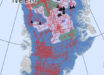
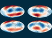
This map shows the California Borderland and its major tectonic features, as well as the locations of earthquakes greater than magnitude 5.5. The dashed box shows the area of the new study. Large arrows show relative plate motion for the Pacific-North America fault boundary. Image credit: Mark Legg.
The new study into the fault-riddled, undersea landscape off of Southern California and northern Baja supports the likelihood that these vertical fault zones have displaced the seafloor in the past, which means they could send out tsunami-generating pulses towards the nearby coastal mega-city of Los Angeles and neighboring San Diego.
“We are dealing with continental collision. That’s fundamental. That’s why we have this mess of a complicated logjam,” said Dr Legg, lead author of paper about the results available online in the Journal of Geophysical Research: Earth Surface.
The logjam Dr Legg referred to is composed of blocks of the Earth’s crust caught in the ongoing tectonic battle between the North American tectonic plate and the Pacific plate. The blocks are wedged together all the way from the San Andreas Fault on the east, to the edge of the continental shelf on the west, from 90 to 125 miles (150 – 200 km) offshore.
These chunks of crust get squeezed and rotated as the Pacific plate slides northwest, away from California, relative to the North American plate. The mostly underwater part of this region is called the California Continental Borderland, and includes the Channel Islands.
By combining seismic and other data from earthquakes with 2,796 miles (4,500 km) of new multibeam bathymetry data collected in 2010, Dr Legg’s team was able to take a closer look at the structure of two of the larger seafloor faults in the Borderland: the Santa Cruz-Catalina Ridge Fault and the Ferrelo Fault.
“The two fault systems are parallel and are capable of large lateral offsets and reverse slip during earthquakes. The geometry of these systems shows evidence of multiple segments that could experience throughgoing rupture over distances exceeding 100 km,” the scientists wrote in the paper.
“Such large faults could even have the potential of a magnitude 8 quake. This continental shelf off California is not like other continental shelves – like in the Eastern U.S.,” said co-author Dr Christopher Sorlien of the University of California at Santa Barbara.
What the team found along the Santa Cruz-Catalina Ridge Fault are ridges, valleys and other clear signs that the fragmented, blocky crust has been lifted upward, while also slipping sideways like the plates along the San Andreas Fault do.
Further out to sea, the Ferrelo Fault zone showed thrust faulting – which is an upwards movement of one side of the fault. The vertical movement means that blocks of crust are being compressed as well as sliding horizontally relative to each other-what the scientists describe as ‘transpression.’
“Transpression on west and northwest trending structures persists as far as 270 km south of the Transverse Ranges; extension persists in the southern Borderland,” the scientists wrote.
“A logjam model describes the tectonic evolution of crustal blocks bounded by strike-slip and reverse faults which are restrained from northwest displacement by the Transverse Ranges and the southern San Andreas fault big bend.”
“Because of their potential for dip-slip rupture, the faults may also be capable of generating local tsunamis that would impact Southern California coastlines, including populated regions in the Channel Islands.”
_____
Mark R. Legg et al. High-resolution mapping of two large-scale transpressional fault zones in the California Continental Borderland: Santa Cruz-Catalina Ridge and Ferrelo faults. Journal of Geophysical Research: Earth Surface, published online May 30, 2015; doi: 10.1002/2014JF003322