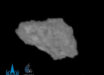
A new image from ESA’s Mars Express orbiter shows part of Aonia Terra, an upland region in the southern highlands of Mars.

This image shows part of the scarred and colorful landscape in Aonia Terra, Mars. The image comprises data gathered by Mars Express’ High Resolution Stereo Camera (HRSC) on April 25, 2022. It was created using data from the nadir channel, the field of view aligned perpendicular to the surface of Mars, and the color channels of the HRSC. Image credit: ESA / DLR / FU Berlin.
Aonia Terra is a region located in the southern hemisphere of Mars.
This region is centered at 60°S 97°W, covers 3,900 km at its broadest extent, and is known for its impressive craters — such as the 200 km-wide Lowell crater
Aonia Terra is named after a feature called Aonia, a dark patch on the surface of Mars that can be seen from Earth, even with rudimentary telescopes.
Aonia was also a region in ancient Greece, a location sacred to the Muses, the goddesses of literature, science and the arts.
“The southern highlands are among the oldest formations on Mars, and were formed 3.8 to 3.5 billion years ago, during the Noachian period,” ESA researchers said.
“The age of a planetary surface can be determined through statistical analysis of the different crater sizes and how frequently they occur.”
“The older a region is, the more craters it will have and the greater number of large craters there will be.”
“Using this method, scientists were able to determine three different periods of Martian history: the Noachian (4.1 to 3.7 billion years ago), the Hesperian (3.7 to 3.3 billion years ago) and the Amazonian (from 3.3 billion years ago to the present day).”
The new image, captured by the High Resolution Stereo Camera (HRSC) aboard ESA’s Mars Express spacecraft on April 25, 2022, shows scarred and colorful — by Martian standards — landscape that makes up Aonia Terra.
The 30 km-wide unnamed crater at the center of the image is nestled within a landscape of winding channels.
The channels appear to be partly filled with a dark material, and in some places, seem to actually be raised above the surrounding land.
“There are a variety of possible explanations for this,” the scientists said.
“Perhaps erosion-resistant sediment settled at the bottom of the channels when water flowed through them. Or perhaps the channels were filled in with lava later on in Mars’ history.”
The image reveals many different colors in the surface around the crater, suggesting that this region of Mars is made up of a variety of materials.
South of the crater, the surface is a warm red, melting into a darker brownish-grey closer to the crater.
In this region, many buttes are visible — these flat-topped towers of rock are created when land is gradually worn away by water, wind or ice.
Inside the crater, a dark dune field rests on a lighter surface. Upon closer inspection, it becomes apparent that the crater is filled with more buttes and cone-shaped hills.
“It is possible to make out a black dune field inside the impact crater. This is made up of small crescent dunes, some of which have merged together,” the researchers said.
“Measuring 5.4 by 2.7 km, it sits atop a light-colored deposit that was probably formed by weathering in combination with water.”
“The black sands are known to be volcanic in origin because they are made up of minerals that could only have been brought to the surface of Mars by volcanism. Their composition also closely resembles that of volcanic ash on Earth.”
“They are referred to as basaltic dunes because they are composed of volcanic minerals and can be found in many places on Mars.”
“Basalts are the most common volcanic rocks on Mars. On Earth, there are only a few instances of these dark dunes, for example in Hawaii, as they only exist where volcanic activity takes place in a dry climate.”
“On closer inspection, one can also discover many small hills and elevations away from the dune field on the crater floor, which stand like knolls in the landscape,” they added.
“This shows that the interior of the crater also consists of many different materials that have come together here.”
“Measurements by the Thermal Emission Imaging System (THEMIS) instrument onboard NASA’s Mars Odyssey spacecraft reveal that the bright deposits have very high thermal inertia, while the remaining material on the crater floor has very low thermal inertia.”
“Thermal inertia is a measure of the consolidation of a material, with high thermal inertia indicating solid rock and low thermal inertia indicating loose material.”
“These different properties confirm the large differences in the composition of the crater infill.”
To the north of the crater, the surface is lighter and smoother. The rims of the main crater and the channels appear less defined.