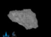
The new image from the High Resolution Stereo Camera (HRSC) aboard ESA’s Mars Express spacecraft shows sections of Ius Chasma and Tithonium Chasma — two scenically different tectonic rifts in the west of Valles Marineris on Mars.

This image, captured by the High Resolution Stereo Camera (HRSC) onboard ESA’s Mars Express on April 21, 2022, shows Ius and Tithonium Chasmata, which form part of Mars’ Valles Marineris canyon structure. Image credit: ESA / DLR / FU Berlin.
When NASA’s Mariner 9 spacecraft reached Mars in 1971 and began to explore the planet from orbit, there was initially great disappointment at the control center: virtually nothing could be seen in the images sent to Earth.
At that time, a global dust storm was raging on Mars, which made it impossible to see the surface. Only the peaks of the highest volcanoes stood out from the monotonous gray.
In early 1972, the Martian weather improved, the dust settled and Mariner 9 began to take a global survey of the Red Planet.
One of the most impressive structures observed was a rift valley up to 4,000 km long, 200 km wide and 7 km deep.
In honor of the mission, this structure, torn open by tectonic forces, was named Valles Marineris — the valleys of Mariner. It is thought to have formed through the drifting apart of tectonic plates.
The new HRSC image shows Ius Chasma (top) and Tithonium Chasma (bottom) — two trenches (or chasma) that form part of western Valles Marineris.
Tithonium Chasma measures approximately 805 km from east to west and Ius Chasma 840 km.
“Whilst these high-resolution images show incredible surface detail, it is only when we look at an elevation map that we realize how spectacularly deep the chasmata are — up to 7 km,” ESA researchers said.
In Tithonium Chasma, a patch of dark sand brings color contrast to the image. This sand may have come from the nearby Tharsis volcanic region.
Next to the dark sand dunes are two light-toned mounds. These ‘mounds’ are more like mountains, rising more than 3 km in height.
Their surfaces have been strongly eroded by Mars’ strong winds, indicating that they are made of a weaker material than the surrounding rock.
Between the two mounds we see a series of smaller bumps. The Mars Express team previously found water-bearing sulfate minerals in this region.
This suggests that these bumps may have formed when liquid that once filled the chasma evaporated, although this theory is still hotly debated.
To the left of the mound that we see fully, we can see parallel lines and debris piles that indicate a recent landslide.
The landslide was caused by the collapse of the canyon wall on the right, and is likely to have occurred relatively recently because it has not been strongly eroded.
The gnarly floor of Ius Chasma is equally fascinating.
As tectonic plates pulled apart, they appear to have caused jagged triangles of rock to form that look like a row of shark teeth.
Over time, these rock formations have collapsed and eroded.