A team of geophysicists at the University of California, Berkeley, proposes that Martian oceans originated several hundred million years earlier than thought, as the Solar System’s largest volcanic system — called Tharsis — formed, and that greenhouse gases enabled the oceans. The team’s theory predicts smaller oceans, more in line with estimates of water underground and at the poles today.
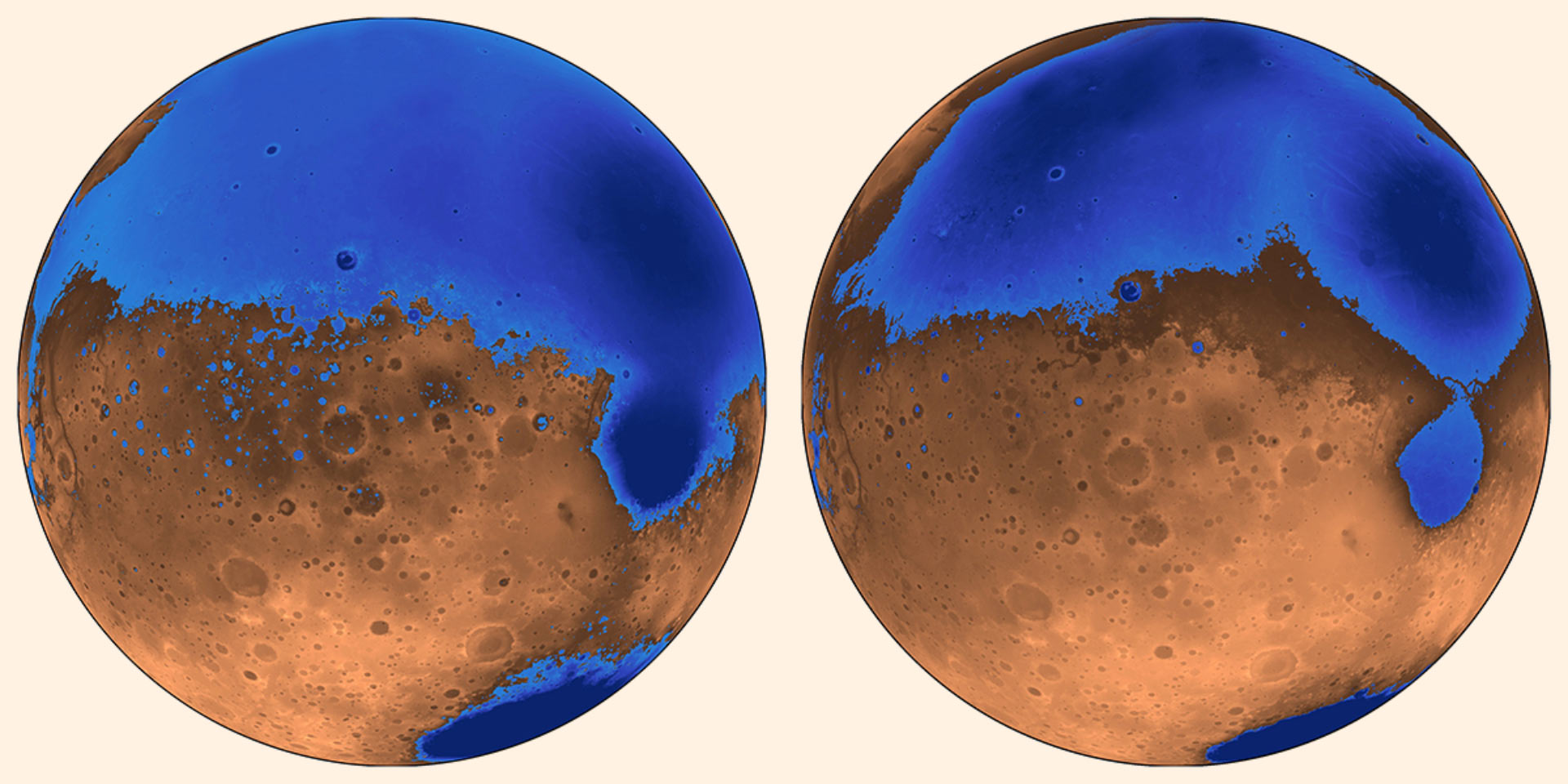
The early ocean known as Arabia (left, blue) would have looked like this when it formed 4 billion years ago on Mars, while the Deuteronilus ocean, about 3.6 billion years old, had a smaller shoreline; both coexisted with the massive volcanic province Tharsis, located on the unseen side of the planet, which may have helped support the existence of liquid water; the water is now gone, perhaps frozen underground and partially lost to space, while the ancient seabed is known as the northern plains. Image credit: Robert Citron, University of California, Berkeley.
“Volcanoes may be important in creating the conditions for Mars to be wet,” said University of California, Berkeley’s Professor Michael Manga.
“Those claiming that Mars never had oceans of liquid water often point to the fact that estimates of the size of the oceans don’t jibe with estimates of how much water could be hidden today as permafrost underground and how much could have escaped into space. These are the main options, given that the polar ice caps don’t contain enough water to fill an ocean.”
The new model proposes that the oceans formed before or at the same time as Tharsis, instead of after Tharsis formed 3.7 billion years ago.
Because Tharsis was smaller at that time, it did not distort Mars as much as it did later, in particular the plains that cover most of the northern hemisphere and are the presumed ancient seabed.
The absence of crustal deformation from Tharsis means the seas would have been shallower, holding about half the water of earlier estimates.
“The assumption was that Tharsis formed quickly and early, rather than gradually, and that the oceans came later,” Professor Manga said.
“We’re saying that the oceans predate and accompany the lava outpourings that made Tharsis.”
“It’s likely that Tharsis spewed gases into the atmosphere that created a global warming or greenhouse effect that allowed liquid water to exist on the planet, and also that volcanic eruptions created channels that allowed underground water to reach the surface and fill the northern plains.”
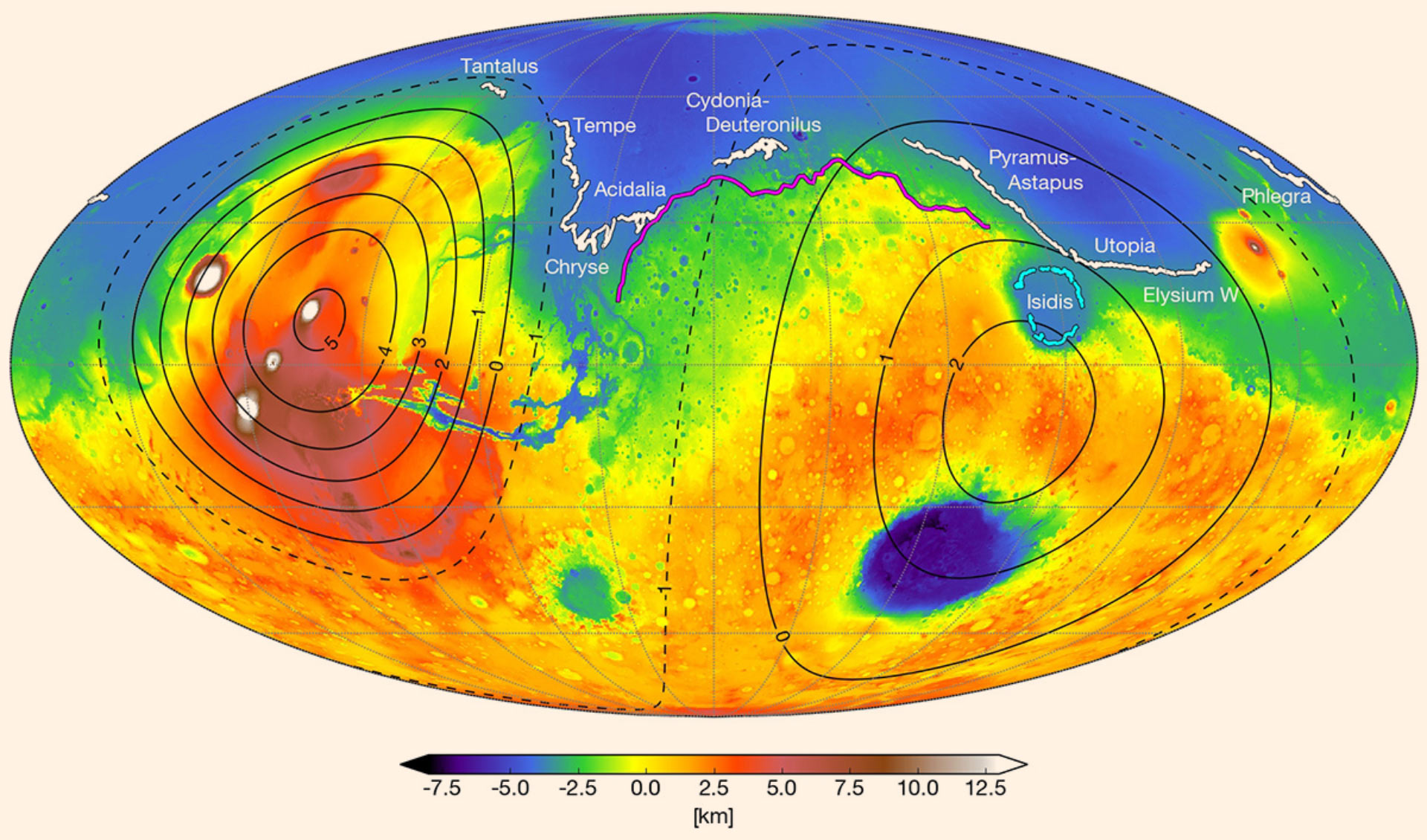
A map of Mars today shows where scientists have identified possible ancient shoreline that may have been etched by intermittent oceans billions of years ago; the irregular elevations of these shorelines can be explained by the growth of the volcanic province called Tharsis some 3.7 billion years ago, which would have deformed the topography and misaligned the shorelines; Arabia (magenta) is more than 4 million years old, while the Deuteronilus (white) and Isidis (cyan) shoreline are several million years younger; the solid contour lines represent the Tharsis bulge (left) and the antipodal bulge it created (right), with dashed contour lines indicating the depressions in between. Image credit: Robert Citron, University of California, Berkeley.
The model also counters another argument against oceans: that the proposed shorelines are very irregular, varying in height by as much as a kilometer, when they should be level, like shorelines on Earth.
This irregularity could be explained if the first ocean, called Arabia, started forming about 4 billion years ago and existed, if intermittently, during as much as the first 20% of Tharsis’ growth. The growing volcano would have depressed the land and deformed the shoreline over time, which could explain the irregular heights of the Arabia shoreline.
Similarly, the irregular shoreline of a subsequent ocean, called Deuteronilus, could be explained if it formed during the last 17% of Tharsis’ growth, about 3.6 billion years ago.
“These shorelines could have been emplaced by a large body of liquid water that existed before and during the emplacement of Tharsis, instead of afterwards,” said Robert Citron, a graduate student at the University of California, Berkeley.
The research is published in the journal Nature.
_____
Robert I. Citron et al. Timing of oceans on Mars from shoreline deformation. Nature, published online March 19, 2018; doi: 10.1038/nature26144