A team of researchers led by Dr Kenneth Tanaka of the U.S. Geological Survey has produced a new global geologic map of Mars that records the distribution of geologic units and landforms on the planet’s surface through time.

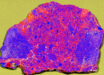
This new global geologic map of Mars depicts the most thorough representation of the planet’s surface; colors show distribution of 44 map units; for example, greens represent mainly lowland and basin units; yellow is relatively young impact material; reds and purples are volcanic units; blues are polar units; and earth tones are apron, transition, and highland units. Image credit: Tanaka, K.L. et al.
“Spacecraft exploration of Mars over the past couple decades has greatly improved our understanding of what geologic materials, events and processes shaped its surface. The new geologic map brings this research together into a holistic context that helps to illuminate key relationships in space and time, providing information to generate and test new hypotheses,” Dr Tanaka said.
Two previous geologic maps of the Red Planet have been published.
The first map appeared in 1978. It was produced at a scale of 1:25,000,000 using low resolution Mariner 9 image data (2–3 km/pixel resolution).
The second map was published in 1986 in three parts at a scale of 1:15,000,000. It incorporated Viking Orbiter image data about an order of magnitude higher in spatial resolution, which provided for much improved landform recognition and crater counting.
The new global geologic map (map sheet in .pdf) portrays the planet much differently than its predecessors and with improved understanding.
It was 7 years in the making and incorporates data from NASA’s Mars Global Surveyor, Mars Odyssey, Mars Reconnaissance Orbiter and by ESA’s Mars Express.
The map records the materials, terrains, and geologic features at 1:20,000,000 scale, assembling them in a detailed geospatial and temporal context.
Dr Tanaka and his colleagues used digital photogeologic mapping techniques to identify and discriminate 44 geologic units (encompassing about 1,300 occurrences) and 12 linear feature types (more than 3,500 individual features mapped).
The map reveals that the surface of Mars is generally older than previously thought.
Units of Noachian age (4.1-3.7 billion years ago) cover roughly 45 percent of the Martian surface, Hesperian-aged (3.7-3.0 billion years ago) units make up 29 percent, the Amazonian (3.0 billion years ago – present) units cover about 26 percent.
All impact basins over 150 km in diameter have been dated and show a dramatically reduced rate of formation over time: more than 65 impact basins for the Early Noachian period, 15 for Middle Noachian, 3 for Late Noachian, 4 for Hesperian, and 2 for Early Amazonian.
The map also confirms previous studies that suggest Mars had been geologically active until the present day.
“This map provides a comprehensive digital geologic database of Mars, useful for guiding exploration and research into its geological history, resources, astrobiology potential, and geophysical and climatological information,” Dr Tanaka said.
_____
Tanaka, K.L. et al. 2014. Geologic map of Mars: U.S. Geological Survey Scientific Investigations Map 3292, scale 1:20,000,000, pamphlet 43 p.; doi: 10.3133/sim3292