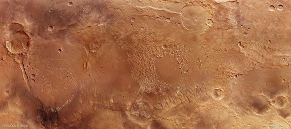
A virtual flight across the Atlantis basin reveals a broad variety of phenomena, etched into this landscape billions of years ago. The animation is based on four image strips acquired between 2008 and 2014 by the High Resolution Stereo Camera on ESA’s Mars Express spacecraft.
The Atlantis basin, originally described in 1930 on a map of Mars by the Greek astronomer Eugene Michel Antoniadi, is located in the southern hemisphere of Mars, in the Phaethontis quadrangle, Sirenum Terrae region.
The basin contains a region of disrupted terrain known as Atlantis Chaos. This region stands out for its highly disrupted landscape structure consisting of several hundred light-colored small peaks and mesas distributed across a nearly circular lowland plain.
These are most likely remnants of outliers – the eroded remains of what was once a continuous high plateau. Originally, it may have consisted of sedimentary deposits that were carried into the basin by the wind and subsequently altered by the influence of water.
The Atlantis basin likely owes its existence to an asteroid impact that took place in the early history of Mars. Now, the circular profile of what could be the crater rim is barely detectable. There are several other large basins in Sirenum Terra – most likely created by asteroid impacts as well.
The newly-released video tour, created by scientists at the Freie Universität Berlin in Germany, takes us above a well-preserved crater bearing traces of sediment at the base and showing visible fissures.

A noticeable feature of the Atlantis basin is the several hundred mesas and small peaks strewn ‘chaotically’ across its roughly 200-km expanse. The uppermost layer of these elevated areas consists of light-colored material. Spectroscopic measurements have shown these consist of phyllosilicates, minerals produced in the presence of water. Image credit: ESA / DLR / FU Berlin / CC BY-SA 3.0 IGO.
Then, we fly over a straight section of a valley of tectonic origin, with rifts on both sides, before continuing across a plain with light-colored sedimentation and a number of flow fronts consisting of solidified, low-viscosity lava.
We are then taken across a large, ‘chaotic area’ with a number of light-colored mesas, before entering a mountainous region, up to 1.24 miles (2 km) in height.
It is possible that standing water once filled the Atlantis basin and the adjoining depressions, which include several impact craters dating back 3 to 4 billion years: Eridania Lake. It could even have covered an area of one million square miles, making it roughly half the size of the Mediterranean.
Ma’adim Vallis – a roughly 435-mile (700 km) outflow channel though to have carried water northwards from the lake to form a deeper-lying expanse in Gusev crater – opens up northwest of Eridania: the antique name for Po Mountain and the Po Valley in Italy. It was there, in the 103-mile (166 km) Gusev crater, where NASA’s rover Spirit landed in January 2004.


