This new image from ESA’s Mars Express orbiter shows the central part of Mangala Valles, a system of channels on Mars. The image was taken by Mars Express’ High Resolution Stereo Camera on July 12, 2015.
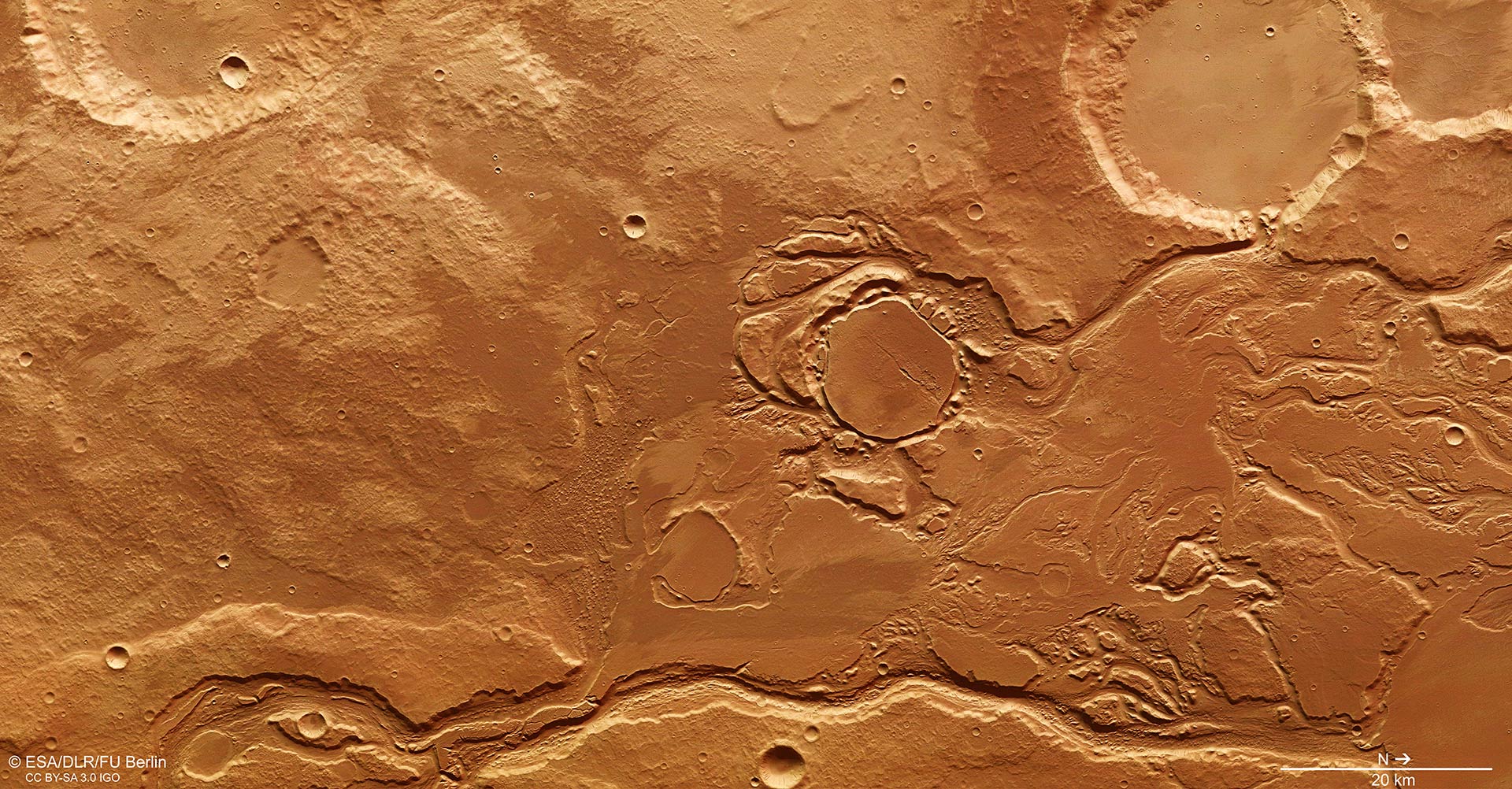
This image of part of the Mangala Valles outflow channel system was acquired by ESA’s Mars Express on July 12, 2015. The region has been subject to intense episodes of flooding, likely triggered by volcanic processes occurring in the nearby Tharsis region. Image credit: ESA / DLR / FU Berlin / CC BY-SA 3.0 IGO.
During the Hesperian period (3.7 to 3.1 billion years ago), strong volcanic activity was present on Mars. Volcanoes spewed low viscosity lava that poured out in masses over the surface and gave rise to extensive plains.
Rising magma prompted the crust to bulge upwards, causing tectonic tensions to develop as a result of the volcanic activity.
In many places, the Martian crust broke up and produced fissures or graben systems such as Valles Marineris.
The Tharsis region – home to several volcanoes, including the Solar System’s largest, Olympus Mons – was formed during this period. At the southwestern slope of this region lie the largest valley system, Mangala Valles, and the smaller Minio Vallis.
The latest image from ESA’s Mars Express orbiter shows the central part of Mangala Valles.
The Mangala Valles’ proximity to volcanic giants likely played an important role in creating the outflow channels seen in this image, which were carved by large volumes of flowing water.
The source of the water is believed to be related to the formation of the Mangala Fossae, an east-west fault system spanning several hundreds of miles.
There, hot, molten rock could have reached the surface in an episode of increased volcanic activity during the formation of the Tharsis region. This activity may have triggered the melting of subsurface ice, and consequently the formation of the water-carved channels.
Several basins and impact craters were also filled with water, with overflows flushing through multiple spillways and towards Amazonis Planitia, the lowlands to the north.
For example, a channel drains into the 17.4 mile (28 km) wide impact crater in the upper right of the main image, breaching its crater wall.
The crater in the center of the image was filled with water and sediments and later eroded back again. Chaotic terrain formed around it, characterized by isolated blocks of surface material that have been chaotically arranged during the release of subsurface water and subsequent surface collapse.
Another example of an infilled and eroded crater lies to the southeast – bottom left in the main image – of this crater.
The chaotic terrain suggests this region may also have had subsurface ice, which experienced multiple episodes of melting and flooding.
A deep channel carves through the landscape along the bottom edge of the image, its inner walls displaying layers, terraces and streamlined islands eroded by the outflowing water.