NASA’s spacecraft orbiting Mars has snapped wintry-looking pictures of the planet’s surface, showing the slopes of an impact crater dusted with carbon dioxide frost.

This image of an area on the surface of Mars, about 1.5 x 3 km in size, was taken by the HiRISE camera aboard the Mars Reconnaissance Orbiter on November 30, 2014. It shows frosted gullies on a south-facing slope within a crater in Sisyphi Planum. In the Martian southern spring, only south-facing slopes retain the frost, while the north-facing slopes have melted. Image credit: NASA / JPL-Caltech / University of Arizona.
The images were captured by the High Resolution Imaging Science Experiment (HiRISE) camera on NASA’s Mars Reconnaissance Orbiter (MRO).
The spacecraft entered its primary science phase on November 6, 2006. The campaign to observe sublimation of the southern seasonal carbon dioxide cap began in the same year.
It is in a Sun-synchronous, roughly polar, 255 x 320 km orbit and is equipped with HiRISE, a push-broom imager with a row of ten CCDs covered with broad-band red filters.
HiRISE provides images at spatial scales down to 0.25 meter per pixel. The data from the detectors are combined on the ground to produce monochromatic images that are typically 20,000 pixels wide, providing a swath of approximately 6 km width.
The two new high-resolution images were captured by HiRISE in November 2014. They show frosted gullies within an impact crater in Sisyphi Planum that is about 35 km in diameter and is located northwards of the Southern polar layered deposits.
Carbon dioxide frost covers much of the region and helps to reveal subtle textures in the landscape.
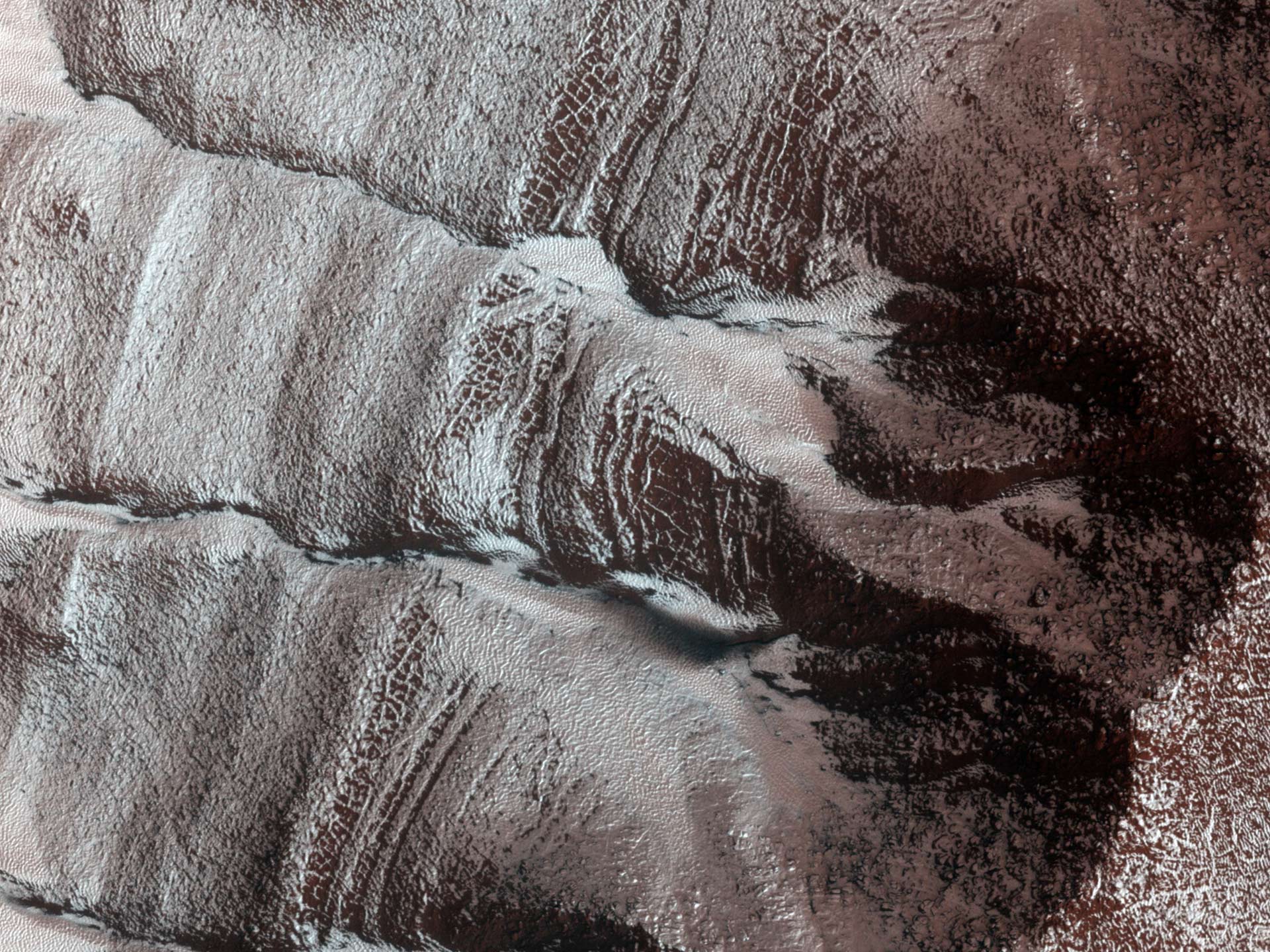
The frosted gullies in this image, captured by the HiRISE camera on November 13, 2014, are located along an irregularly shaped pit (about 15 km wide) within the impact crater in Sisyphi Planum. Image credit: NASA / JPL-Caltech / University of Arizona.
Evidence for a variety of processes abound in this region. The dark, low albedo spots along some of the gullies and on the frosted debris aprons, especially along the base of the layered terrain are likely areas of defrosting, where carbon dioxide frost sublimates during the Martian southern spring.
Periglacial terrain forming polygonal patterns suggests that the region is rich in near surface ground ice and volatiles.
Ice-rich landslide-like forms and sinuous ridges are also common, owing to the unstableness of the layered sediment within the crater.