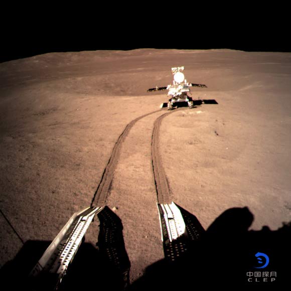
On January 3, 2019, China National Space Administration’s Chang’e-4 probe successfully landed on the eastern floor of Von Karman, a 180-km- (112 mile) wide crater located within an even larger impact crater known as the South Pole-Aitken basin, becoming the first spacecraft to land safely on the Moon’s farside. The Yutu-2 rover, equipped with the Lunar Penetrating Radar (LPR), was deployed to the surface about 12 hours later. Now, researchers report the observations made by the LPR instrument during the first two lunar days. The LPR images indicate that the subsurface is primarily made of low-loss, highly porous, granular materials with embedded boulders of different sizes.
“We found that the signal penetration at the Chang’e-4 (CE-4) site is much greater than that measured by the previous spacecraft, Chang’e-3 (CE-3), at its near-side landing site,” said Professor Chunlai Le, deputy director-general of the National Astronomical Observatories of the Chinese Academy of Sciences (NAOC).
“The subsurface at the CE-4 landing site is much more transparent to radio waves, and this qualitative observation suggests a totally different geological context for the two landing sites.”
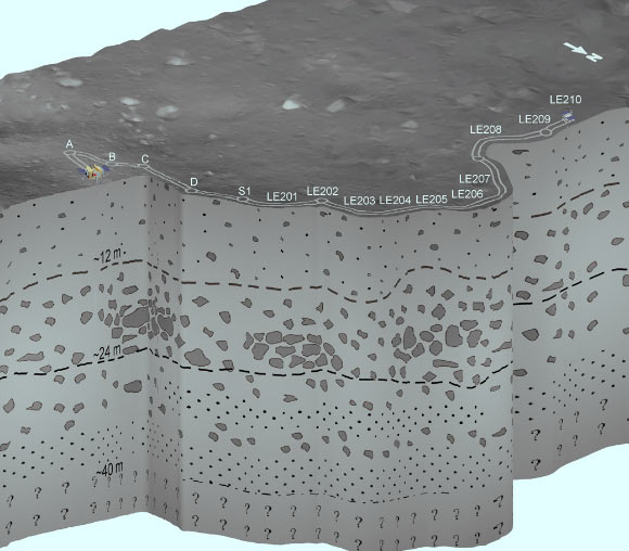
Dr. Li and colleagues used the LPR instrument to send radio signals deep into the surface of the Moon, reaching a depth of 40 m by the high frequency channel of 500 MHz — more than three times the depth previously reached by CE-3.
The data allowed the researchers to develop an approximate image of the subsurface stratigraphy.
“Despite the good quality of the radar image along the rover route at the distance of about 106 m, the complexity of the spatial distribution and shape of the radar features make identification of the geological structures and events that generated such features quite difficult,” said Dr. Yan Su, also from NAOC.
The scientists combined the radar image with tomographic data and quantitative analysis of the subsurface.
They concluded that the subsurface is essentially made by highly porous granular materials embedding boulders of different sizes.

Schematic representation of the subsurface geological structure at the CE-4 landing site inferred from LPR observations. The subsurface can be divided into three units: Unit 1 (up to 12 m) consists of lunar regolith, unit 2 (depth range, 12 to 24 m) consists of coarser materials with embedded rocks, and unit 3 (depth range, 24 to 40 m) contains alternating layers of coarse and fine materials. Image credit: Li et al, doi: 10.1126/sciadv.aay6898.
“The results of the radar data collected by the LPR during the first two days of lunar operation provide the first electromagnetic picture of the farside subsurface structure and the first ‘ground truth’ of the stratigraphic architecture of an ejecta deposit,” they said.
“The results illustrate, in an unprecedented way, the spatial distribution of the different products that contribute to from the ejecta sequence and their geometrical characteristics,” Professor Li said.
“This work shows the extensive use of the LPR could greatly improve our understanding of the history of lunar impact and volcanism and could shed new light on the comprehension of the geological evolution of the Moon’s farside.”
The results were published in the journal Science Advances.
_____
Chunlai Li et al. 2020. The Moon’s farside shallow subsurface structure unveiled by Chang’E-4 Lunar Penetrating Radar. Science Advances 6 (9): eaay6898; doi: 10.1126/sciadv.aay6898


