A team of scientists from Lamont-Doherty Earth Observatory at Columbia University has discovered paleolake basin situated beneath the ice sheet in northwest Greenland; geomorphological analysis and hydrological modeling indicate that the basin once hosted a lake with a surface area of up to 7,100 km2 and a volume of up to 580 km3; it may be hundreds of thousands or millions of years old and contain unique fossil and chemical traces of past climates and life.

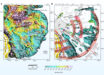
Paxman et al. mapped a huge ancient lake basin (outlined here in red) below the Greenland ice; redder colors signify higher elevations, green ones lower; a stream system incised into the bedrock that once fed the lake is shown in blue. Image credit: Paxman et al., doi: 10.1016/j.epsl.2020.116647.
“This could be an important repository of information, in a landscape that right now is totally concealed and inaccessible,” said Dr. Guy Paxman, lead author of a paper published in the journal Earth and Planetary Science Letters.
“We’re working to try and understand how the Greenland ice sheet has behaved in the past. It’s important if we want to understand how it will behave in future decades.”
Dr. Paxman and colleagues mapped out the ancient lake bed by analyzing data from airborne geophysical instruments that can read signals that penetrate the ice and provide images of the geologic structures below.
Most of the data came from aircraft flying at low altitude over the ice sheet as part of NASA’s Operation IceBridge.
The geophysical images show a network of at least 18 apparent onetime stream beds carved into the adjoining bedrock in a sloping escarpment to the north that must have fed the lake. The image also show at least one apparent outlet stream to the south.
The researchers calculated that the water depth in the onetime lake ranged from about 50 to 250 m.
“The basin may have formed along a now long-dormant fault line, when the bedrock stretched out and formed a low spot,” they said.
“Alternatively, but less likely, previous glaciations may have carved out the depression, leaving it to fill with water when the ice receded.”
Sediments in the basin appear to range as much as 1.2 km thick. What they might contain is a mystery.
Material washed out from the edges of the ice sheet have been found to contain the remains of pollen and other materials, suggesting that Greenland may have undergone warm periods during the last million years, allowing plants and maybe even forests to take hold.
But the evidence is not conclusive, in part because it is hard to date such loose materials.
The newly-discovered lake bed, in contrast, could provide an intact archive of fossils and chemical signals dating to a so-far unknown distant past.
“The basin may be an important site for future sub-ice drilling and the recovery of sediment records that may yield valuable insights into the glacial, climatological and environmental history of the region,” the scientists said.
“With the top of the sediments lying 1.8 km below the current ice surface, such drilling would be daunting, but not impossible.”
_____
Guy J.G. Paxman et al. A fault-bounded palaeo-lake basin preserved beneath the Greenland Ice Sheet. Earth and Planetary Science Letters, published online October 28, 2020; doi: 10.1016/j.epsl.2020.116647