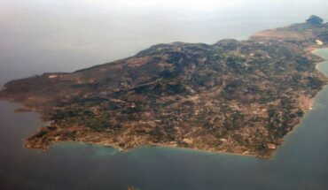
Geography News

Jul 21, 2025 by News Staff

Submarine canyons are deep, large-scale incisions found on most of the world’s continental margins. In Antarctica, they are widespread features driving oceanographic processes with significant implications for global climate and circulation. The understanding of their oceanographic, climatic, geological and ecological significance is limited by the detail, accuracy and extent of canyon inventory. In a new study, scientists from University College...

Apr 30, 2024 by News Staff

Accurate assessment of global river flows and stores is critical for informing water management practices, but current estimates of global river flows...

Mar 1, 2024 by News Staff

Sightings of unidentified anomalous phenomena (UAP), formerly known as unidentified flying objects (UFOs), have been reported throughout history. Given...

Dec 20, 2023 by News Staff

The new-submerged Northwest Shelf of Sahul — the combined landmass of Australia and New Guinea at times of lower sea level — was a vast area...

Oct 25, 2023 by News Staff

Geoscientists from Durham University and elsewhere have discovered a landscape that appears to have been formed by rivers at least 14 million years ago...

Jun 9, 2022 by News Staff

After nine years of gathering, cleaning, processing and interpolating data, an international team of researchers this week released the second version...

Jan 19, 2022 by News Staff

A multinational team of researchers has catalogued data on 773 subglacial lakes — repositories of ancient climate conditions, provide habitats for...

Dec 28, 2021 by News Staff

A duo of MIT researchers has created the most detailed atlas of the world’s largest oxygen deficient zones, biogeochemical regions of the global ocean...

Nov 11, 2020 by News Staff

A team of scientists from Lamont-Doherty Earth Observatory at Columbia University has discovered paleolake basin situated beneath the ice sheet in northwest...

Jul 29, 2020 by News Staff

A team of scientists from Europe, the United States, Canada, South Korea, Greenland and China has produced the most detailed depth map of the Arctic Ocean...

Jul 1, 2020 by News Staff

A team of scientists from GNS Science, New Zealand’s leading provider of Earth, geoscience and isotope research and consultancy services, has created...

Dec 16, 2019 by News Staff

BedMachine Antarctica is a new bed topography map based on ice thickness data from different research institutes dating back to 1967, encompassing nearly...

Sep 13, 2018 by News Staff

A team of cartographers and researchers from the University of Minnesota and the Ohio State University has produced a high-resolution terrain map of Antarctica...

Sep 28, 2017 by News Staff

Earlier this year, Zealandia was confirmed as Earth’s seventh continent, but little is known about it because it’s 94% submerged under water. After...

Feb 14, 2017 by Natali Anderson

Zealandia — a 4.9 million km2 region of the southwest Pacific Ocean — was once part of the ancient supercontinent Gondwana and today it is...

Oct 29, 2015 by News Staff

In November 2014, Schmidt Ocean Institute’s research vessel Falkor discovered a seamount, or underwater mountain, 28,500 feet (8,700 m) on the ocean...

Sep 24, 2015 by News Staff

According to a duo of Australian scientists, Aboriginal society has preserved memories of Australia’s coastline dating back to 11,000 – 5,300 BC. Members...

Jul 14, 2015 by News Staff

A team of researchers aboard an ocean-going research vessel called RV Investigator has discovered a cluster of 50-million-year-old volcanoes off the coast...

Feb 18, 2015 by News Staff

Innovative techniques that use satellites to monitor ocean acidification are set to revolutionize the way that scientists study the Earth’s oceans....

Nov 27, 2014 by News Staff

An international group of scientists using data from ESA’s Gravity field and steady-state Ocean Circulation Explorer (GOCE) has created the most accurate...