Scientists using the High Resolution Stereo Camera aboard ESA’s Mars Express spacecraft have captured a stunning new image of Hellas Chaos, a large region in the enormous Hellas basin on Mars.
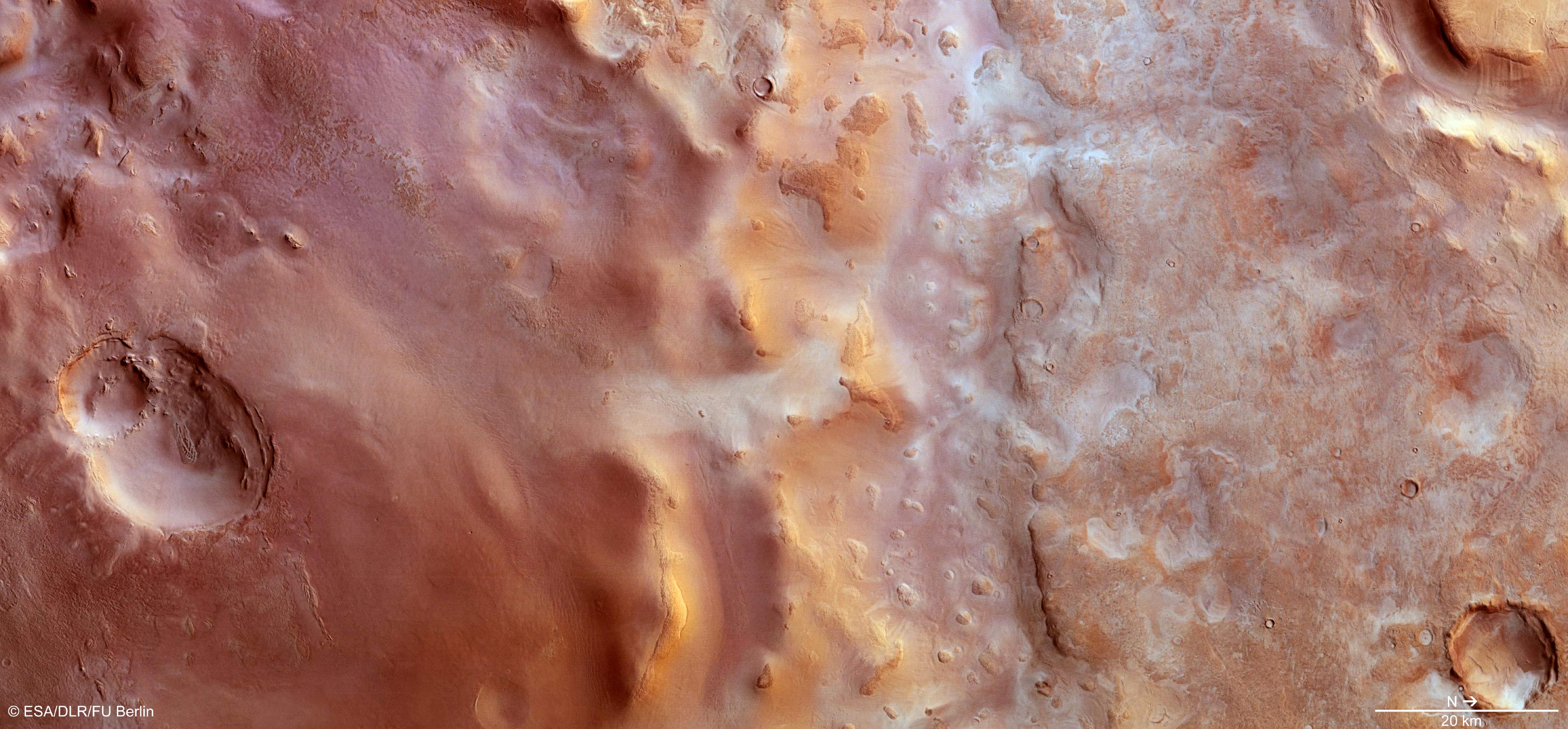
Hellas Chaos stretches roughly 200 km north–south and for about 500 km in an east–west direction. It shows a variety of landforms, from large impact craters containing wind-blown dunes or flat-topped mesas, to ridges and troughs with rough knobs of material protruding from the surface. The region is also dusted with carbon dioxide frost. North is to the right and west is at the top. The image was captured by Mars Express on 23 January 2014. Image credit: ESA / DLR / FU Berlin.
Hellas basin is a giant impact basin in the southern hemisphere of Mars and one of the Solar System’s largest impact basins, with a diameter of 2,300 km.
It is thought to have formed about 4 billion years ago, during the heavy bombardment that subjected all the inner Solar System planets to a heavy rain of asteroids and comets.
Since its formation, the basin has been sculpted by wind, ice, water and volcanic activity. It is also where most global dust storms on Mars originate.
Hellas Chaos lies in the southern central part of the basin. Its origin is widely debated.
One idea is that large amounts of sediments were deposited inside the Hellas Basin and later eroded by wind and water. Another idea suggests that volcanic activity might be the cause. The context map shows extensive lava flows around the ‘chaos’, perhaps related to the nearby volcano Amphitrites Patera. Alternatively, floods of lava inside the Hellas basin, following the formation of the basin itself, could have given rise to the structures seen in this region today.
Much of Hellas Chaos in the new image is dusted with carbon dioxide frost, although in places the underlying surface is exposed.
In contrast to the frosty terrain, the ridges running through the centre of the image appear golden, probably from the low Sun angle of around 25 degrees. Flows of sediments are also visible on some portions of their flanks.
Immediately to the north (right) of the ridges, the elevation drops down into a large east–west trough (best seen in the topography map), the floor of which displays many small knobs with a rough surface.
To the right again, the curved outline of large sublimation pits can be seen, interspersed with polygonal-patterned terrain.
These features develop as a result of the contraction and relaxation during freeze–thaw cycles as the seasons change.
Distinct impact craters can also be seen in this scene. For example, at the bottom right, one with a layered rim exhibits some dark internal streaks that could be dunes shaped by prevailing winds.
In the top-right corner, a large flat-topped ‘mesa’ rises from the surface.
The flanks of the mesa are covered with dust that seems to flow down into the surrounding depression.
Here, the material is pushed together, presumably from successive flows producing parallel ridges of piled sediment layers.
Smaller craters can also be seen in the right-hand part of the image, some with debris blankets that appear fluidized, indicating the presence of subsurface ice that melted during the impacts that created the craters.
In the left-hand portion of the image, there are also two large, noteworthy features.
At the lower left, there appear to be the remains of two overlapping craters, with the eroded rim of the smaller one sitting inside a larger crater. Both display eroded walls and host interesting internal features.
Meanwhile, in the top-left corner of the image, a region of lower elevation is littered by curious ridges and blocks of material that exhibit the same rough textures as the knobs in the central part of the image.