New research suggests that during the Late Cretaceous epoch to the Early Paleogene epoch (80-50 million years ago), much of the southwestern United States had elevations in excess of 3 km (10,000 feet) and looked more like the Tibetan plateau.

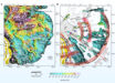
This map shows locations of samples analyzed to estimate crustal thickness during the Laramide orogeny. Text in white boxes is the average crustal thickness and average age for locations (labeled in brown) with over 5 samples. CRM – Catalina-Rincon Mountains, BM – Baboquivari Mountains. Image credit: Chapman et al, doi: 10.1130/G47117.1.
“Earth’s crust floats in the mantle just like an iceberg floats in the water, with a little bit sticking out above the surface,” said Dr. Jay Chapman, a researcher in the Department of Geology and Geophysics at the University of Wyoming.
“When the crust is thicker, the height of mountains and the elevation of the land surface are higher, just like the height of an iceberg sticking out of the water is taller if the overall iceberg is larger.”
In the study, Dr. Chapman and his colleagues analyzed the chemistry of igneous rocks to determine how thick Earth’s crust was in the past and then related the thickness to elevation.
They determined that the crust in southern Arizona was once 35.4 miles (57 km) thick, which is twice as thick as it is today.
“While the ancient mountains were forming, magma intruded into the crust and formed rocks like granite,” Dr. Chapman said.
“When the crust was really thick, the magmas experienced extreme pressure from the weight of all the rocks above them, which caused distinctive changes in the types and the chemistry of the minerals that formed those rocks.”
One of the interesting questions the study raises is how the crust in southern Arizona became so thick in the past.
“The most common way to make really thick crust is for tectonic plates to converge or collide, which produces large earthquakes and faults that stack rock masses overtop one another,” Dr. Chapman explained.
“The prevailing view of southern Arizona is that there was never enough faulting in the area to make the thickness of crust we observe. It is a bit of a conundrum as to how such thick crust was generated.”
The study authors are now tackling this problem and searching for ancient faults in southern Arizona that could help explain how the thick crust became so thick.
In addition to helping understand plate tectonic processes, the study may help explain why copper is so abundant in southern Arizona.
“Several previous studies have noted a correlation between large copper ore deposits and regions of thick crust,” Dr. Chapman said.
“For example, there are many copper mines in the Andes Mountains in Chile. The results of this study strengthen that correlation and may aid in exploration efforts.”
The study is published in the journal Geology.
_____
James B. Chapman et al. Geochemical evidence for an orogenic plateau in the southern U.S. and northern Mexican Cordillera during the Laramide orogeny. Geology, published online November 22, 2019; doi: 10.1130/G47117.1