Using satellite images from Google Earth, Canadian scientists have found that fishing weirs off the coast of Persian Gulf countries could be catching up to 6 times more fish than what’s being officially reported. Their study, reported in the ICES Journal of Marine Science, provides the first example of fisheries catch estimates from space.

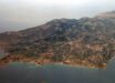
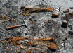
Canadian scientists used Google Earth images to estimate the number of fishing weirs along the Persian Gulf coast. This image shows a weir off the coast of Iran. Image credit: Google Earth / Dalal Al-Abdulrazzak / Daniel Pauly.
Intertidal fishing weirs are semi-permanent traps that take advantage of tidal differences to catch a wide variety of marine species.
Used in Southeast Asia, Africa and parts of North America, some weirs can be more than 100 m long.
“This ancient fishing technique has been around for thousands of years. But we haven’t been able to truly grasp their impact on our marine resources until now, with the help of modern technology,” said study first author Dalal Al-Abdulrazzak, a PhD student at University of British Columbia.
The researchers estimated that there were 1,900 fishing weirs along the coast of the Persian Gulf during 2005 and that they caught 31,000 tones of fish that year.
The majority of the weirs were found in Bahrain (50 percent), followed by Iran (37 percent) and Kuwait (5 percent).
Bahrain also leads in estimated catch (54 percent), followed by Iran (39 percent).

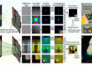
Surveyed coast of the Persian Gulf with assigned pins for each visible weir. Weirs were found in all countries except Iraq. Image credit: Dalal Al-Abdulrazzak / Daniel Pauly.
The official number reported by the countries in the region to the UN Food and Agriculture Organization was 5,260 tones.
The study shows the potential for using remote-sensing approaches, such as satellite imagery, to validate catch statistics and fisheries operations in general.
“Time and again we’ve seen that global fisheries catch data don’t add up,” said second author Dr Daniel Pauly, also from University of British Columbia.
“Because countries don’t provide reliable information on their fisheries’ catches, we need to expand our thinking and look at other sources of information and new technologies to tell us about what’s happening in our oceans.”
______
Bibliographic information: Dalal Al-Abdulrazzak and Daniel Pauly. 2013. Managing fisheries from space: Google Earth improves estimates of distant fish catches. ICES J. Mar. Sci., published online November 25, 2013; doi: 10.1093/icesjms/fst178