The two Martian hemispheres are drastically different; the smooth northern lowlands sit up to 3 km below the rugged southern highlands, and the surface in the northern regions appears to be far younger than the ancient swaths of the south. Where these regions meet, they sometimes form a transition area filled with a wide range of intriguing geological features, patterns and processes — a type of landscape unique to the Red Planet known as fretted terrain. Fretted terrain is found in a couple of key areas on Mars, and an especially good example, named Deuteronilus Mensae, can be seen in these new images from the High Resolution Stereo Camera on ESA’s Mars Express spacecraft.

This image shows a region of Mars named Deuteronilus Mensae. The oblique perspective view was generated using a digital terrain model and Mars Express data gathered on February 25, 2018. Image credit: ESA / DLR / FU Berlin / CC BY-SA 3.0 IGO.
As is common with fretted terrain, it contains a mix of cliffs, canyons, scarps, steep-sided and flat-topped mounds (mesa), furrows, fractured ridges and more.
These features were created as flowing material dissected the area, cutting through the existing landscape and carving out a web of winding channels.
In the case of Deuteronilus Mensae, flowing ice is the most likely culprit.
Planetary scientists believe that this terrain has experienced extensive past glacial activity across numerous Martian epochs.
It is thought that glaciers slowly but surely ate away at the plains and plateaus that once covered this region, leaving only a scattering of steep, flat, isolated mounds of rock in their wake.
Smooth deposits cover the floor itself, some marked with flow patterns from material slowly moving downhill — a mix of ice and accumulated debris that came together to form and feed viscous, moving flows of mass somewhat akin to a landslide or mudflow here on Earth.
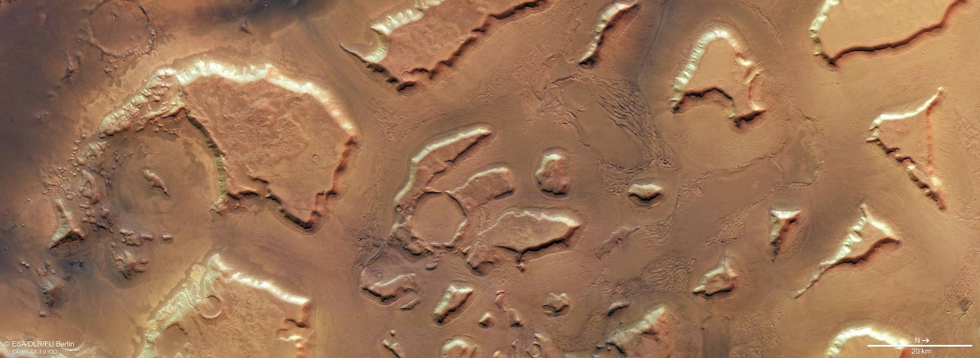
This image from ESA’s Mars Express orbiter shows Deuteronilus Mensae. It comprises data gathered on February 25, 2018. Image credit: ESA / DLR / FU Berlin / CC BY-SA 3.0 IGO.
According to previous studies, most of the features seen here do indeed contain high levels of water ice.
Estimates place the ice content of some glacial features in the region at up to 90%.
This suggests that, rather than hosting individual or occasional icy pockets and glaciers, Deuteronilus Mensae may actually represent the remnants of an old regional ice sheet.
This ice sheet may once have covered the entire area, lying atop the plateaus and plains.
As the Martian climate changed this ice began to shift around and disappear, slowly revealing the rock beneath.
Overall, the features seen in these Mars Express images are reminiscent of the rock- and debris-covered glaciers found in cold regions of Earth.