A new image acquired by the High Resolution Stereo Camera (HRSC), on board ESA’s Mars Express spacecraft, shows a run out of the Aurorae Chaos region.
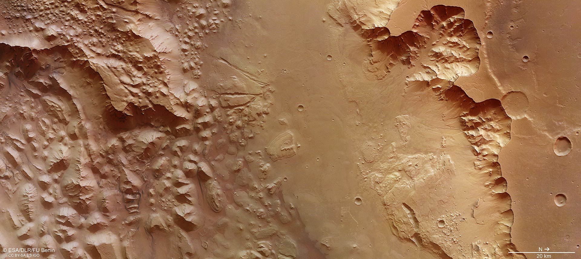
This image focuses on a section of Aurorae Chaos on Mars. Vast volumes of water once flooded through this deep chasm on the planet that connects Valles Marineris to the planet’s northern lowlands. The image was taken by Mars Express’ High Resolution Stereo Camera on July 16, 2015. The image was acquired using the nadir channel of the camera, which is directed vertically down onto the surface of Mars. Image credit: ESA / DLR / FU Berlin / CC BY-SA 3.0 IGO.
Aurorae Chaos, a very extensive ‘chaotic terrain,’ is an eastern continuation of the massive Valles Marineris graben system on Mars.
Chaotic terrain refers to regions with dozens, or even hundreds, small peaks and mesas. They may sometimes constitute a random pattern over many thousands of square miles on the Red Planet – or just have a ‘chaotic’ arrangement.
Chaotic terrains are believed to have developed by collapse, triggered by the sudden release of water when giant underground ice reservoirs melted.
The source of the heat could be nearby volcanoes or an asteroid impact. When the water drains away, the surface falls over the newly formed cavities and the landscape collapses onto itself.
Aurorae Chaos measures around 440 miles (710 km) across and plunges 3 miles (4.8 km) below the surrounding terrain.
This region lies northeast of the point at which the Capri Chasma and Eos Chasma valleys meet, connecting the grabens of Valles Marineris with Ganges Chasma. It is rich in features pointing to wet episodes in the history of the planet.
Dominating the southern (left) portion of the scene are numerous jumbled blocks.
Towards the center of the image is the smoother floor of Ganges Chasma, comprising mostly alluvial deposits, and which transitions into a steep scarp and a cratered plateau to the north (right).
The northern plateau shares the same elevation as that on the southern side, but does not exhibit similar levels of catastrophic collapse.
However, the cliff tops display small channels and the walls show evidence of landslides. Material closest to the main chasma floor appears stepped, which could reflect different water or ice levels over time.
Another feature can be seen towards the upper center and to the left in the image, where a pair of faults cuts through a collapsed block, and perhaps extends into the southern plateau at the top of the image.
The faults could be the result of a tectonic event that occurred after the formation of the chaotic terrain, or they could be from simple subsidence.