New images from the High Resolution Imaging Science Experiment (HiRISE) camera on NASA’s Mars Reconnaissance Orbiter reveal never-before-observed details about Martian ice sheets, including that some begin just a few feet below Mars’ surface and extend to depths greater than 300 feet (100 m). The findings are published in the journal Science.

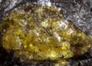
This high-resolution HiRISE image shows a detailed subsection of an icy scarp on Mars in enhanced color. Image credit: NASA / JPL / University of Arizona / USGS.
“There is ice under roughly a third of the Martian surface, which records the recent geologic history of Mars,” said lead author Dr. Colin Dundas, a research geologist with the Astrogeology Science Center at the U.S. Geological Survey.
“What we’ve seen here are cross-sections through the ice that give us a 3D view with more detail than ever before.”
“Having this degree of detail is an important contribution to the growing body of knowledge about conditions on Mars.”
Although water ice deposits are known to exist from previous Mars missions, Dr. Dundas and co-authors analyzed the vertical structure and thickness of the exposed subsurface ice sheets using high-resolution imagery and topography from MRO’s HiRISE instrument.
They examined north and south pole-facing erosional slopes, known as scarps, in eight locations around Mars, all in the mid-latitudes.

This HiRISE image shows an icy scarp on Mars in the context of a broader area. Image credit: NASA / JPL / University of Arizona / USGS.
These scarps are thought to be formed by a process called sublimation, where ice is lost to the atmosphere by transformation into water vapor without ever turning into liquid.
Similar to ice cores recovered from the Earth’s surface, these ice sheets may preserve a record of ice deposition and past climate on Mars.
Images of the erosional scarps reveal geologic features of the ice, such as banded patterns and color variations due to layering.
Such details suggest ice layers with different proportions of ice and dust that could have formed under varying climate conditions.
“There is low rock and dust content in the exposed ice,” the researchers said.
“This means that relatively pure water ice, capped by only a thin layer of ice-cemented rock and dust, may be readily accessible to future exploration missions.”
_____
Colin M. Dundas et al. 2018. Exposed subsurface ice sheets in the Martian mid-latitudes. Science 359 (6372): 199-201; doi: 10.1126/science.aao1619