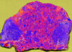
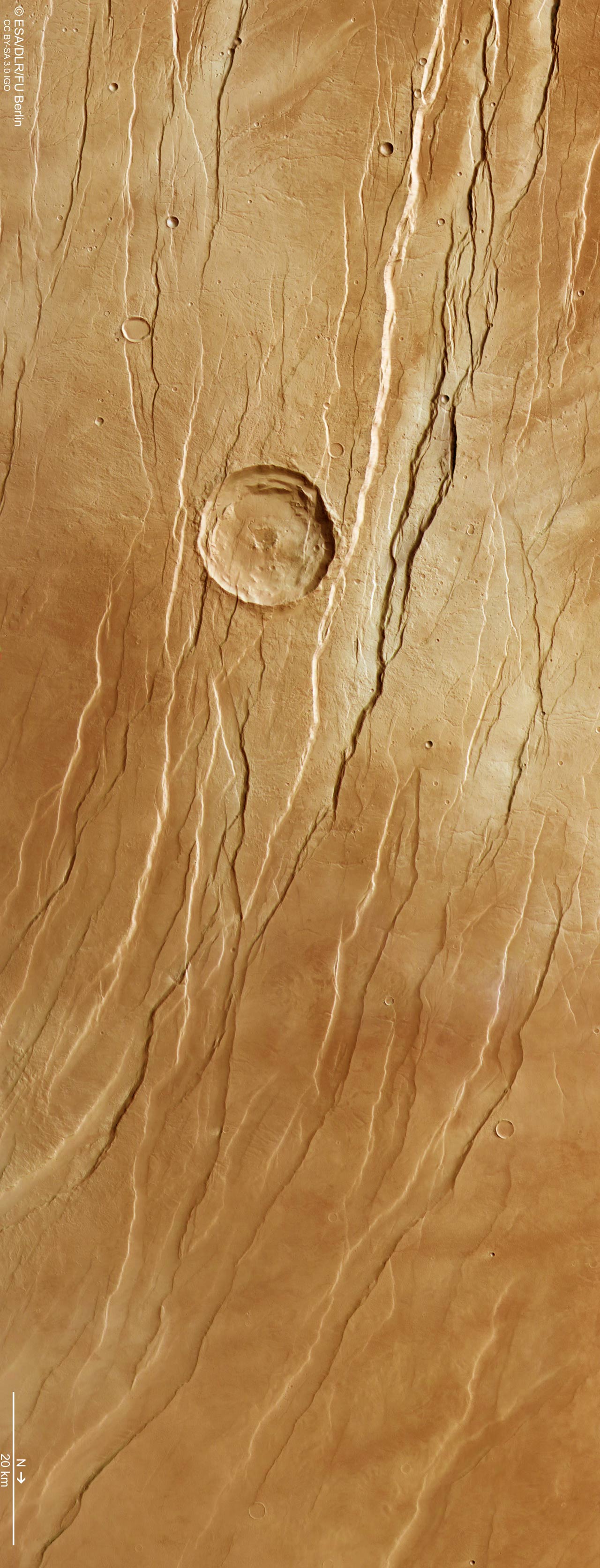
A new image from ESA’s Mars Express shows a network of long grooves and scratches in Tantalus Fossae, a large fault system in the Arcadia quadrangle of Mars.
This image, taken on July 19, 2021 by the High Resolution Stereo Camera (HRSC) on board ESA’s Mars Express spacecraft, shows part of Tantalus Fossae on Mars. Image credit: ESA / DLR / FU Berlin / CC BY-SA 3.0 IGO.
While not quite so dramatic in its formation, Tantalus Fossae is a noticeable feature on Mars.
This system of troughs flanks a sprawling, low-relief Martian volcano named Alba Mons, running along the volcano’s eastern side.
The fossae were created as the summit of Alba Mons rose in elevation, causing the surrounding surface to become warped, extended and broken.
The Tantalus Fossae faults are a great example of a surface feature known as grabens; each trench formed as two parallel faults opened up, causing the rock between to drop down into the resulting void.
The same features can be found on the western side of Alba Mons, forming an incomplete ring around the volcano.
Overall, this volcano’s associated grabens stretch out for up to 1,000 km in length, up to 10 km in width, and are up to 350 m deep.
“This area is named after Tantalus, a son of Zeus and Plouto who, according to Greek legend, betrayed the gods and was forced by Hades to stand in water beneath a fruit tree,” ESA researchers said.
“When he tried to drink the water retreated, and when he tried to eat the branches moved beyond his reach — a punishment known as the torments of Tantalus.”
Throughout this image from the High Resolution Stereo Camera (HRSC) on board ESA’s Mars Express spacecraft, numerous grabens can be seen running roughly northeast (bottom-right) to southwest (top-left).
These structures are thought to have formed not at the same time but one after the other, providing planetary scientists the opportunity to reconstruct a past timeline and picture of what created this dramatic landscape.
The large impact crater at the center of the image, for example, is crosscut by grabens, indicating that it was already present before the volcano was uplifted to create the Tantalus Fossae faults.
The second-largest impact crater — far smaller and to the bottom-left of the central crater — appears to superpose the faults, and is therefore likely to be younger.
Upon closer look, many small, branching valleys can be seen across this region. These valleys appear to cut directly through the grabens, and so are assumed to be older.
As shown most clearly in the associated topographic view, the northern (right) part contains far lower terrain than the southern (left) part — in places, as much as 3 km lower in altitude.
“We would expect any small, branching valleys to run along the slopes of Alba Mons and merge where the ground is lowest, but this is not seen here, implying that the valleys must originate from more ancient times — before Alba Mons rose to sculpt this terrain into what we see today,” the scientists said.