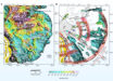
A team of scientists from GNS Science, New Zealand’s leading provider of Earth, geoscience and isotope research and consultancy services, has created new bathymetric and tectonic maps of Zealandia, Earth’s eighth continent.

The tectonic map of Zealandia. Image credit: GNS Science.
Zealandia has 4.9 million km2 of landmass and once made up approximately 5% of the area of Gondwana, the ancient supercontinent that included Antarctica and Australia.
Roughly 94% of the area of Zealandia currently is submerged.
“The new maps of Zealandia are a scientific benchmark — but they’re also more than that,” said lead author Dr. Nick Mortimer, a geologist with GNS Science.
“They are a way of communicating our work to our colleagues, stakeholders, educators and the public.”
“We’ve made these maps to provide an accurate, complete and up-to-date picture of the geology of the New Zealand and southwest Pacific area — better than we have had before,” he added.
“Their value is that they provide a fresh context in which to explain and understand the setting of New Zealand’s volcanoes, plate boundary and sedimentary basins.”

The bathymetric map of Zealandia. Image credit: GNS Science.
The new maps of Zealandia can also be accessed through a new website called E Tūhura — Explore Zealandia (TEZ).
“TEZ provides the perfect way for users to explore geoscience data from the comfort of their homes or offices,” said Dr. Vaughan Stagpoole, a crustal geophysicist with GNS Science.
“Users can zoom and pan around different thematic geoscience webmaps of the region.”
“They can readily view and interrogate the maps and turn layers on or off.”
“They can also query features in the layers and generate custom maps of their own.”