An international team of geoscientists from the United States, Canada and Europe has discovered a large impact crater beneath the Hiawatha Glacier in remote northwest Greenland. A paper on the discovery was published in the journal Science Advances.

This is a photo illustration of the airplane during the survey, radar waves and the actual radar image. Image credit: NASA.
The Hiawatha impact crater is approximately 19.2 miles (31 km) wide and lies under an ice sheet that is 0.6 miles (1 km) thick.
The scientists believe this crater was formed by a 0.6-mile wide iron asteroid that slammed into the Earth at the end of the Pleistocene epoch, perhaps as recently as 12,000 years ago.
The crater was identified with data collected between 1997 and 2014 by NASA’s Program for Arctic Regional Climate Assessment and Operation IceBridge, and supplemented with more data collected in May 2016 using the Multichannel Coherent Radar Depth Sounder.
“We’ve collected lots of radar-sounding data over the last couple of decades, and glaciologists put these radar-sounding datasets together to produce maps of what Greenland is like underneath the ice,” said team member Dr. John Paden, a researcher in the Center for Remote Sensing of Ice Sheets at the University of Kansas.
“Researchers were looking at the map and saw this big, craterlike depression under the ice sheet and looked at satellite imagery and — because the crater is on edge of the ice sheet — you can see a circular pattern there as well.”
“The two combined made a really strong case for this being an impact-crater site. Based on this discovery, a detailed radar survey was conducted in May 2016.”
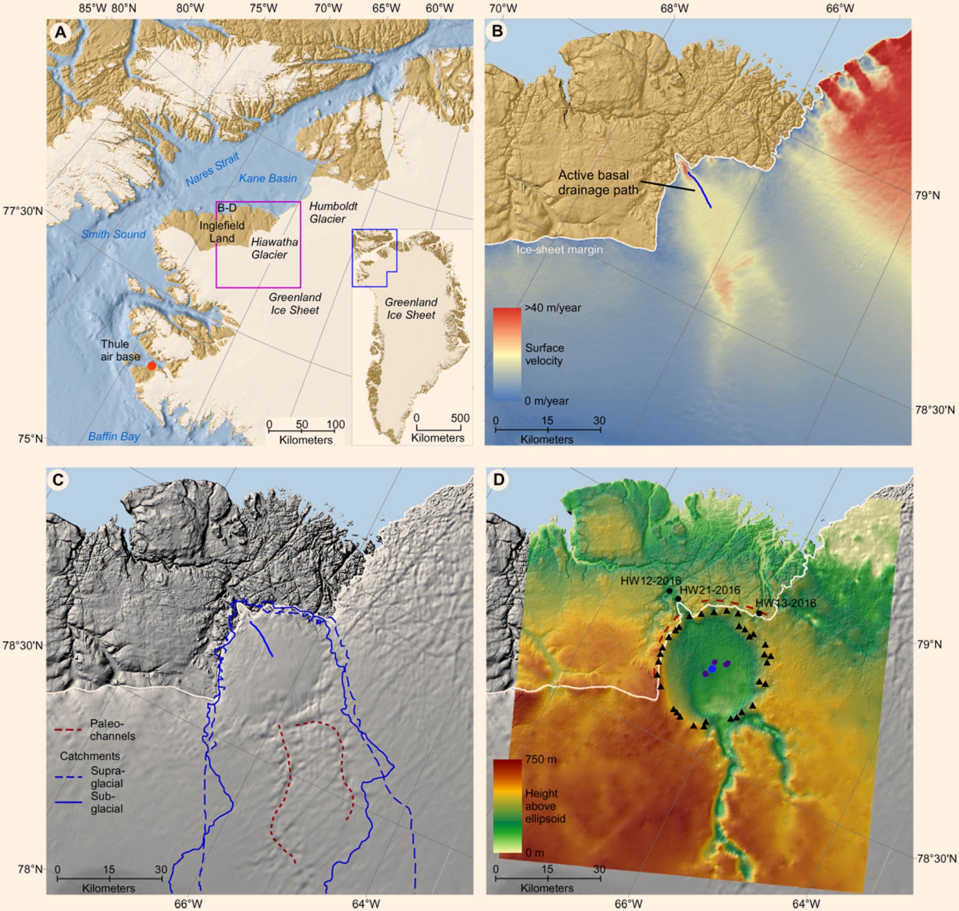
Geomorphological and glaciological setting of Hiawatha Glacier, northwest Greenland: (A) regional view of northwest Greenland; inset map shows location relative to whole of Greenland; magenta box identifies location of (B) to (D); (B) a 5-m ArcticDEM mosaic over eastern Inglefield Land; colors are ice surface velocity; blue line illustrates an active basal drainage path inferred from radargrams; (C) hillshade surface relief based on the ArcticDEM mosaic, which illustrates characteristics such as surface undulations; dashed red lines are the outlines of the two subglacial paleochannels; blue lines are catchment outlines, i.e., solid blue line is subglacial and hatched is supraglacial; (D) bed topography based on airborne radar sounding from 1997 to 2014 NASA data and 2016 Alfred Wegener Institute data; black triangles represent elevated rim picks from the radargrams, and the dark purple circles represent peaks in the central uplift; hatched red lines are field measurements of the strike of ice-marginal bedrock structures. Image credit: Kjaer et al, doi: 10.1126/sciadv.aar8173.
To confirm the satellite and radar findings, the team performed subsequent ground-based studies of glaciofluvial sediment from the largest river draining the crater.
The work showed the presence of ‘shocked quartz and other impact-related grains’ that include glass.
“These rocks and glassy grains are likely produced from impact melting of grains in the meta-sedimentary bedrock,” the scientists said.
The Hiawatha impact crater likely formed during the Pleistocene, as this age is most consistent with inferences from presently available data. However, even this broad range in time remains uncertain.
Southwest of the crater, the team found a region rich in possible debris ejected from the impact, which could help to narrow the date range.
“There would have been debris projected into the atmosphere that would affect the climate and the potential for melting a lot of ice, so there could have been a sudden freshwater influx into the Nares Strait between Canada and Greenland that would have affected the ocean flow in that whole region,” Dr. Paden said.
“The evidence indicates that the impact probably happened after the Greenland Ice Sheet formed, but we are still working on the precise dating.”
_____
Kurt H. Kjaer et al. 2018. A large impact crater beneath Hiawatha Glacier in northwest Greenland. Science Advances 4 (11): eaar8173; doi: 10.1126/sciadv.aar8173