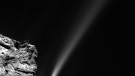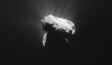
ESA’s Rosetta orbiter yesterday witnessed 67P/Churyumov-Gerasimenko making its closest approach to the Sun. The comet and the spacecraft were 186 million km from the Sun, about a third of the distance at rendezvous last August. This Rosetta image was taken just one hour before 67P/Churyumov-Gerasimenko reached perihelion, the closest point to the Sun along its 6.5-year orbit. The image was taken around 327 km from the comet. Image credit: ESA /...
Space Exploration News